Walk 1979 - printer friendly version
Culross Heritage Walk
Author - Lou Johnson
Length - 1.5 miles / 2.4 km
Ascent - 200 feet / 61 metres
Grade - easy
Start - OS grid reference NS982858
Lat 56.054191 + Long -3.6361566
Postcode KY12 8JL (approx. location only)
The Royal Burgh of Culross lies on the northern shore of the Firth of Forth. Coal and salt were two commodities that have been important in this area and these were shipped from Culross harbour to the Low Countries and the Baltic particularly in the 16th century. These ships returned with red pantiles used as ballast and today many of the town's houses are still roofed with these.
Today the town still retains much charm with the Culross Palace, a former merchant's house, one of the most visually interesting buildings in the town. Other buildings of note include the ruins of Culross Abbey and the adjacent Abbey Church, the Study (built 1610) with its Outlook Tower, and many cottages also restored to their former glory.
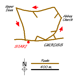
This short but interesting walk starts from the car park (Grid ref. NS982858) located overlooking the Forth Estuary. From here walk along West Green into the centre of the town soon reaching the Sandhaven around which there are many fine buildings including the Town House with its fine clock tower. Tucked away to your left is Culross Palace with its interesting kitchen gardens.
Just past the Town House, bear left into Back Causeway. This cobbled street leads you past many interesting cottages to reach Mercat Cross with the Study on your left. Continue ahead into Tanhouse Brae passing more interesting cottages. Climbing steadily the street name changes to Kirk Street and quite soon you reach the ruins of the Abbey on your right. A short way further up the hill, turn right to reach the west entrance to Culross Abbey Church. Of particular interest are the gravestones in the Churchyard. Many of the older stones have symbols showing the person's trade. You might also find the skull and crossbones insignia rather an unusual adornment for a graveyard!
Exit the church and walk back to the road used for the ascent. Bear right past the cottage on your right (note the 'eye' windows on the west gable) and continue along this quiet lane to reach a junction (Grid ref. NS981863). Turn left here and follow the lane towards Upper Dean. Ignore the first lane descending on your left but continue west to Upper Dean where you take the first lane on the left (West Kirk Road). This leads gently downhill soon becoming the Slate Loan, which leads to the main road along the shore. Almost immediately opposite is the car park where you began.
Messaging & Social Media
Message Walking Britain and follow the latest news.

Mountain Weather
Stay safe on the mountains with detailed weather forecasts - for iOS devices or for Android devices.