Walk 1982 - printer friendly version
Hurley Circular Walk
Author - Lou Johnson
Length - 5.1 miles / 8.3 km
Ascent - 320 feet / 97 metres
Grade - easy
Start - OS grid reference SU825840
Lat 51.54887 + Long -0.81159399
Postcode SL6 5NB (approx. location only)
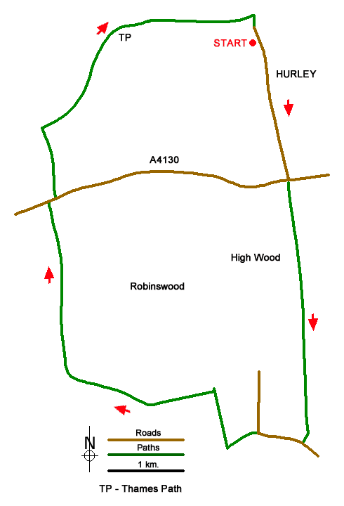
Starting from Hurley this Berkshire walk heads south to climb through High Wood and across farmland to reach Ladyeplace. The route continues past the Dew Drop Inn, convenient for refreshments, before continuing through a partially wooded landscape across the northern flank of Ashley Hill. The walk then passes Hurley Chalk Pit Nature Reserve before turning north to reach the River Thames. A short section along the Thames Path National Trail completes the route back to Hurley.
The start is the small pay and display car park in Hurley (grid ref. SU825840). After parking exit the car park and turn right along High Street. Continue ahead for 800 metres to reach Henley Road (A4130). Take the footpath opposite and slightly right through a metal kissing gate (grid ref. SU827831). Follow the grassy path south across farmland. The path soon climbs the escarpment and enters High Wood. Continue ahead (south) crossing two tracks. Just over a kilometre beyond the wood you reach Honey Lane near Ladyeplace (grid ref. SU828815) at a metal kissing gate.
Turn right along the lane. You are now following part of the Knowl Hill Bridleway Circuit (KHBC). Reaching a junction, go straight ahead (signed to the Dew Drop Inn). At the next junction turn right soon passing the Inn on your right. Continue ahead for a further 300 metres to reach a junction of paths (grid ref. SU823818). Turn left still following a section of KHBC). After 400 metres along a clear track, you reach a junction with a clear track. Turn right and after 150 metres fork left off the clear track to continue along KHBC. You soon pass the nature reserve on your left. Continue ahead descending north down the escarpment to Henley Road (grid ref. SU812830).
Cross the road with care and turn right. Take the first footpath on the left (fingerpost hidden in a hedge). Continue north ignoring a path on your right to reach the River Thames. Turn right along the Thames Path for nearly two kilometres back to Hurley. Reaching a bridge (where the Thames Path turns left), turn right and follow the enclosed path back to the start in Hurley.
Messaging & Social Media
Message Walking Britain and follow the latest news.

Mountain Weather
Stay safe on the mountains with detailed weather forecasts - for iOS devices or for Android devices.