Walk 2118 - printer friendly version
Beinn Eighe traverse including Black Carls, Torridon Walk
Author - Stephen Boulton
Length - 12.5 miles / 20.3 km
Ascent - 4700 feet / 1424 metres
Grade - hard
Start - OS grid reference NG958568
Lat 57.555034 + Long -5.4148097
Postcode IV22 2ET (approx. location only)
This walk is about 18 km or 13 miles, mostly over rocky terrain when up high. It should be saved for a clear day as the ridge is spectacular and the views of Liathach, Glen Torridon and the surrounding mountains should not be missed. This route is extracted from the summary of routes contained in Walk 2116 which also contains the photos and summary map showing the main options.
You'll need two cars, or you'll face a long walk (c.9 km) back down the A896 road through Glen Torridon to retrieve your car at the end of the day. if you can, park one on the A896 near Cromasaig (grid ref NH024610), just south of Kinlochewe. There's not much in the way of parking spaces here without obstructing a passing place, so it might be best to leave the car in Kinlochewe itself (Grid ref. NH0127619, this adds about an extra 1 km to the walk.
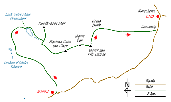
Drive the other car down the glen to the car park near the bridge over the Allt a'Choire Dhuibh Mhor (grid ref. NG958568). This burn runs between Liathach and Beinn Eighe before passing under the road. Follow the signposted path to the Coire Mhic Nobuil. This curves north and heads between the east end of Liathach on your left and the west end of Beinn Eighe on the right.
Shortly before the Lochan a'Choire Dhuibh head right (north) on a path which contours around the base of Sail Mhor on your right to reach the outflow of the Loch Coire Mhic Fhearchair. Climb up the stone path to reach the loch, whereupon is revealed the great sight of the Triple Buttress of Beinn Eighe, across the loch under the summit of Coinneach Mhor. This is a great place to stop for a break, a remote and peaceful location.
Cross the loch outflow and head around the east side of the loch, following the path which brings you to below the Triple Buttress before it strikes off left and climbs past several other lochans to reach the foot of a scree slope up to the ridge. It may be easier to scramble up the rocks to the right of the scree slope rather than up the scree itself. It looks steep when first viewed from beside the loch outflow, but up closer it's an easy scramble.
Upon reaching the ridge admire the view ahead to Spidean Coire nan Clach, the second of Beinn Eighe's two Munros, before turning left to head up the short distance, about 1 km over easy ground, to reach Ruadh-stac Mor, the other Munro. From here fine views north are unveiled, across to Coigach in the north and Slioch round to the north east. Retrace your steps to the bealach where you emerged from the scree scramble. Then climb ahead of you (south) to reach a cairn just to the east of Coinneach Mhor.
To the west lie Coinneach Mhor and Sail Mhor, which is a Munro Top. However this route goes left walking eastwards along the main ridge of Beinn Eighe. Superb views of the back of Liathach emerge on your right, well worth stopping to have a look at. The rocky ridge undulates but it is fairly easy going to rise to Spidean Coire nan Clach. The trig point is not at the highest point of this Munro.
To continue the ridge walk head further east across a bealach to reach Sgurr Ban, and then over another rocky dip to climb to Sgurr nan Fhir Duibhe. If you have chosen your day well then superb views accompany you all the way. At Sgurr nan Fhir Duibhe head north from Sgurr nan Fhir Duibhe to cross the Black Carls. Several interesting scrambling manoeuvres will be required to make it across this short section of broken ridge, and you may be prudent to down scramble to the right (east) to avoid some of the steeper clefts in the rock. If you do this it's easy to pick a route back up to rejoin the ridge.
Once over the Black Carls you will emerge at the cairn of Creag Dhubh, from where an obvious path descends right (east) directly to the road. This is a good track, the upper part of which is scree and the lower part of which is a well-maintained and easy-going path to end the day. There's a small steep section down to cross a burn at one point, but apart from that the going is good and you can turn round to admire the silhouette of the Black Carls in the evening sunshine. Join the A896 at Cromasaig and turn left to walk to Kinlochewe to retrieve your transport.
Messaging & Social Media
Message Walking Britain and follow the latest news.

Mountain Weather
Stay safe on the mountains with detailed weather forecasts - for iOS devices or for Android devices.