Walk 2121 - printer friendly version
Crimsworth Dean, Lumb Bridge & Hardcastle Crags Walk
Author - Lou Johnson
Length - 7.5 miles / 12.2 km
Ascent - 1800 feet / 545 metres
Grade - moderate
Start - OS grid reference SD988280
Lat 53.74837 + Long -2.0196758
Postcode HX7 7LN (approx. location only)
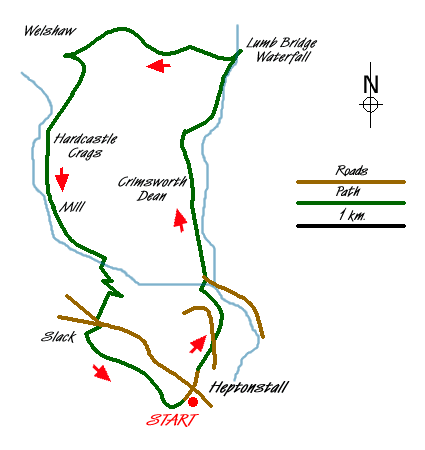
This South Pennine walk is full of interest. Starting from an unspoilt hilltop village with lots to see the route explores two valleys and crosses open moorland. The start is the village of Heptonstall where there a number of parking options. There are a number of parking options and this walk is based on the car park and picnic area at (Grid ref. SD988280).
Exit this car park and turn right into the village. Before starting the walk it is worth exploring the Church and its fascinating churchyard. The latter contains the ruins of the church destroyed by storms in 1847 and some very interesting gravestones, which reflect the wealth of this village in times gone by. As a whole the village has an unspoilt feel with many buildings retaining their character.
With your exploration complete, take Northgate and passing one of the oldest Methodist chapels in England take the signed footpath on your right (Grid ref. SD987281). This path drops steeply to a road. Cross this and continue downhill towards Hebden Water, which is followed uphill to a footbridge. Cross this bridge and follow a rough lane up to a road. Turn left and then right onto a signed bridleway (Grid ref. SD988291).
This track leads onto a tarmac lane. Turn right here and continue uphill. Follow this lane, which degenerates into a track, for just over 2 kilometres as you pass through the beautiful valley of Crimsworth Dean. Leaving the woodland behind, you reach open country. Reaching a footpath sign (Grid ref. SD988312) bear right downhill. This path soon leads to Lumb Bridge and a pretty waterfall, which offers a perfect spot for a picnic. Retrace your steps uphill to the derelict Farm (The Nook). Go straight across (with the ruins on your right) and walk west along a walled lane crossing the flanks of Shackleton Knoll.
The onward route is way-marked and leads you downhill to a lane by the attractive hamlet of Walshaw. Turn sharp left onto this lane. After the lane bends to the right take, the right fork signposted Hardcastle Crags (Grid ref. SD975309) and follow this track as it descends through mature woodland to Gibson Mill (refreshments in season). From here follow the riverside path beside Hebden Water. Cross the river at the third set of stepping stones (Grid ref. SD977292).
Turn left on the other side of the river and follow the narrow path uphill. Just after the Youth Hostel on your left, turn right up a narrow signed path. This gains height quickly and includes a zigzag to reach a walled path (Grid ref. SD978289), which is followed up to the road in the village of Slack. Cross straight over and follow the signed path between houses and past their gardens to reach a track (Grid ref. SD976285). Turn left onto this wide track.
Bear left at the next junction of tracks and continue to a tarmac lane. Walk uphill and, just before this lane bears left, take the path on the right. This leads along the top of a dramatic gritstone outcrop with Colden Water far below. Care is needed in places as there is a significant drop on your right hand side. Reaching a waymark (Grid ref. SD985278) turn left into Heptonstall passing the church to return to the start.
Messaging & Social Media
Message Walking Britain and follow the latest news.

Mountain Weather
Stay safe on the mountains with detailed weather forecasts - for iOS devices or for Android devices.