Walk 2125 - printer friendly version
Edge Hill & Ratley from Radway Walk
Author - Lou Johnson
Length - 5.4 miles / 8.8 km
Ascent - 900 feet / 273 metres
Grade - easy/mod
Start - OS grid reference SP371482
Lat 52.1308660 + Long -1.4594293
Postcode CV35 0UN (approx. location only)
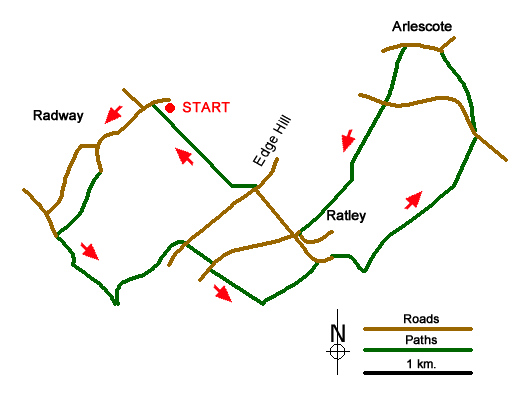
Edge Hill is part of a steep escarpment and is famous for the battle during the English Civil War in 1642 which was fought nearby. The start of the walk is the village of Radway at the foot of the escarpment where limited on street parking is available (grid ref. SP371482). After parking and making sure you are not causing inconvenience to local residents, walk south-west through the village towards the parish church. Where the road bends to the right, continue straight ahead down a lane for approximately 200 metres to locate on a signed footpath on your right at the right hand end of a row of houses (grid ref. SP368478). This leads south-west across fields to reach King John's lane (grid ref. SP366474).
Turn left and walk on a rising path that climbs the escarpment and enters woodland. At the top of the climb turn left onto the Centenary Way (grid ref. SP369470). After 600 metres you reach a path junction with the Battlefields Trail (grid ref. SP373474). Turn right to reach a road. Cross the road to continue down an enclosed path to another road. Turn right and in a short way take the footpath on your left (grid ref. SP375472) remaining on the Battlefields Trail. This leads across two fields with the hedge to your left to reach a path junction (grid ref. SP378470). Turn left here and continue with the Battlefields Trail passing Manor Farm on your right to reach the road in Ratley (grid ref. SP382473).
Turn right and follow the road. Just after the church (on your right) the road bends sharp right (grid ref. SP384473). Here a track goes half left. Leave the track as it bends left and continue ahead on the signed path which descends across fields into a shallow valley before climbing again to pass Camp Barn Farm on your right to reach a road (grid ref. SP392481). Cross the road with care and follow the onward path as it descends through scattered trees and continues to reach the road through Arlescote village (grid ref. SP389486).
Turn left through the village and take the first footpath on your left. This is the Centenary Way and it is followed across a road and through fields to reach a road in Ratley village (grid ref. SP380474). Turn right along the road to a T-junction. Take the footpath opposite and descend through trees to reach a path junction after approximately 150 metres. Turn right (north-west) and follow the path across a large field to reach the road in Radway.
Messaging & Social Media
Message Walking Britain and follow the latest news.

Mountain Weather
Stay safe on the mountains with detailed weather forecasts - for iOS devices or for Android devices.