Walk 2142 - printer friendly version
Severn Valley from Grimley Walk
Author - Peter Lane
Length - 5.0 miles / 8.1 km
Ascent - 320 feet / 97 metres
Grade - easy
Start - OS grid reference SO836606
Lat 52.243337 + Long -2.2416083
Postcode WR2 6LT (approx. location only)
A rural Worcestershire walk setting out along the Severn Way and returning via pleasant fields and meadows.
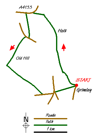
This pleasant walk commences in the sleepy village of Grimley on the River Severn. With no through traffic, this village is a quiet spot to start and finish the walk with the bonus of the Wagon Wheel pub just opposite the Church should your fancy take you there! Route finding on the outward journey is straightforward, however the return journey requires some skill with a map and careful attention to these notes.
Park on the road as near as possible to the Church (but not right in front of the school), grid reference SO836606. Enter the churchyard and walk past the garden of remembrance, along the wall to a kissing gate. Through this, turn left along the edge of the field and follow round as it turns right. Pass either side of the hedge ahead towards the quarry. The route is waymarked the Severn Way now for a couple of miles.
The right of way does pass directly through the quarry and is well signed. However, the quarry owners prefer you to take a safer route to the right, passing it on three sides before rejoining the main path. The choice is yours, but watch out for large vehicles if you choose the direct quarry route.
Past the quarry, enter an enclosed path, cross a stream via a footbridge and emerge via a stile onto a tarmac road. The route now is pretty straightforward passing Top Barn Industrial Estate, Holt Castle and Church (both in local red sandstone). When the concrete road turns to the left and the Severn Way departs over a stile to the right down towards the river, continue on the concrete road to Thatched Lodge and emerge onto the A4133.
Turn left up this main road and after 300 meters there is a stile in the hedge with a fingerpost pointing into a field. Follow this through the field (pretty obvious) emerging either at the gate opposite Naunton Cottages or the official stile further up the field. On the A443 cross to Naunton Cottages and proceed up the access road to Northingtown Farm.
There is now a travesty of justice with respect to the right of way. Just before reaching the main gate of Northingtown Farm, the official path turns left into the back garden of a private house through a beautiful archway and crosses the poor home-owner's back garden. There is a waymark. Far be it from me to suggest deviating from the right of way, but for your information only, entering the vast quadrangle of this prosperous commercial farm and taking an immediate left would in theory take you to the same point as crossing the garden.
The route continues down an access drive that descends to a stile on the left after about 150 metres. Entering the field, head for the farm buildings on the hill (Old Hill) and emerge onto the access drive for the Farm (in theory the right of way is to the right of the buildings, but it doesn't really matter that much). Walk down the lane from Old Hill Farm to a post box and sign to Elm Hill. When the well made path turns left, there is a waymarked route going to the right into a pleasant meadow planted with trees. Head diagonally across this and locate a dilapidated stile. Cross and keep to the right of a barn to cross another stile on the right into a field. Turn left and follow the path to a fence and stile from where a series of pools is seen.
Pass the pools on the left hand side and descending along the hedge-line locate a stile in a depression near an unmarked stream, crossing into a field. After 100 metres the path crosses the stream (on your right) into a field. From here, head up the bank towards a clump of trees. When the hedge-line comes into sight, locate a gap with a rusty red painted gate. Through this the path reaches a traditional duck pond and curves left. Ahead is a stile with waymarks going straight on and right. Cross and go right up the bank, heading for the top right corner of the field. Pass over another dilapidated stile and down some steps to Walton Lane. Return (left) along this to the A443.
Cross the A443, turn left a few metres then right to join the access road to Grimley. A short distance along this road is a stile opposite and a straight path heading through the middle of the field that goes directly to the Church, whose tower is clearly visible ahead. Follow this over a conveyor belt part way along back to the village.
Messaging & Social Media
Message Walking Britain and follow the latest news.

Mountain Weather
Stay safe on the mountains with detailed weather forecasts - for iOS devices or for Android devices.