Walk 2155 - printer friendly version
Mossdale & Cotterdale Walk
Author - Lou Johnson
Length - 7.9 miles / 12.8 km
Ascent - 950 feet / 288 metres
Grade - easy/mod
Start - OS grid reference SD858907
Lat 54.3116940 + Long -2.2197603
Postcode DL8 3LN (approx. location only)
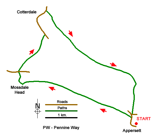
This walk in Upper Wenseleydale starts from Appersett. The route follows the River Ure upstream to Mossdale Head from where the walk climbs out of Mossdale across The Highway to descend into Cotterdale. The walk initially follows Cotterdale Beck before joining the Pennine Way for a short distance before returning to the start.
Parking is available by the village green in Appersett (grid ref. SD858907). After parking walk west out of the village along the A684. Cross the bridge over Widdale Beck and take the first signed footpath on the left (signed Mossdale Head 2 miles). Cross the wall stile and turn right. The path initially runs parallel to the road before turning left to run beside the River Ure. The path (tracks in places) crosses many fields and is generally waymarked and continues close to the river to Mossdale Head. After crossing Mossdale Beck, ignore the tracks going left and right, and climb the field with a wall on your right. After a short climb the path drops down to the A684 at Thwaite Bridge (grid ref. SD826923).
Take the signed path opposite which climbs through trees to a stile. Cross the stile and head half-right uphill to a stile in the top right hand corner. Continue half-right up to the next stile. Continue in the same direction downhill and continue to a lane in Cotterdale (grid ref. SD833933). Turn left into Cotterdale. Continue through the hamlet and turn right across a footbridge over West Gill (grid ref. SD833940). The next section across fields requires careful navigation with the relevant OS 1:25000 map proving useful. The path uses a succession of gates and stiles to reach the Pennine Way (grid ref. SD856922) in just over three kilometres from Cotterdale.
Turn right down the Pennine Way and continue to join a walled track. At the end of the first field on the right, turn right onto a footpath running beside wall on your right. The path continues downhill to cross Broad Carr Sike on a small footbridge (grid ref. SD858912). Continue across a meadow to a small gate and the A684. Turn left along the A684 taking care as the grass verge is narrow. Be particularly careful cross the bridge over the River Ure and return along the road back to Appersett.
Messaging & Social Media
Message Walking Britain and follow the latest news.

Mountain Weather
Stay safe on the mountains with detailed weather forecasts - for iOS devices or for Android devices.