Mossdale & Cotterdale from Appersett
Yorkshire Dales Walk
Nat Park - Yorkshire Dales - Wensleydale
County/Area - North Yorkshire
Author - Lou Johnson
Length - 7.9 miles / 12.8 km Ascent - 950 feet / 288 metres
Time - 4 hours 50 minutes Grade - easy/mod
Maps 

| Ordnance Survey Explorer OL30 | Sheet Map | 1:25k | BUY |
| Anquet OS Explorer OL30 | Digital Map | 1:25k | BUY |
Walk Route Description
Click image to see photo description.
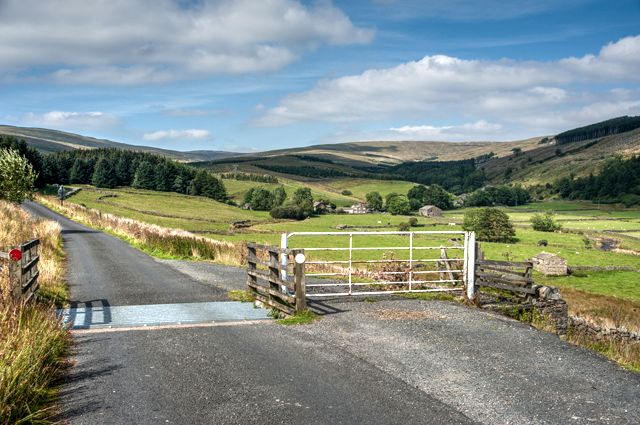
This walk in Upper Wenseleydale starts from Appersett. The route follows the River Ure upstream to Mossdale Head from where the walk climbs out of Mossdale across The Highway to descend into Cotterdale. The walk initially follows Cotterdale Beck before joining the Pennine Way for a short distance before returning to the start.
Parking is available by the village green in Appersett (grid ref. SD858907). After parking walk west out of the village along the A684. Cross the bridge over Widdale Beck and take the first signed footpath on the left (signed Mossdale Head 2 miles). Cross the wall stile and turn right. The path initially runs parallel to the road before turning left to run beside the River Ure. The path (tracks in places) crosses many fields and is generally waymarked and continues close to the river to Mossdale Head. After crossing Mossdale Beck, ignore the tracks going left and right, and climb the field with a wall on your right. After a short climb the path drops down to the A684 at Thwaite Bridge (grid ref. SD826923).
Take the signed path opposite which climbs through trees to a stile. Cross the stile and head half-right uphill to a stile in the top right hand corner. Continue half-right up to the next stile. Continue in the same direction downhill and continue to a lane in Cotterdale (grid ref. SD833933). Turn left into Cotterdale. Continue through the hamlet and turn right across a footbridge over West Gill (grid ref. SD833940). The next section across fields requires careful navigation with the relevant OS 1:25000 map proving useful. The path uses a succession of gates and stiles to reach the Pennine Way (grid ref. SD856922) in just over three kilometres from Cotterdale.
Turn right down the Pennine Way and continue to join a walled track. At the end of the first field on the right, turn right onto a footpath running beside wall on your right. The path continues downhill to cross Broad Carr Sike on a small footbridge (grid ref. SD858912). Continue across a meadow to a small gate and the A684. Turn left along the A684 taking care as the grass verge is narrow. Be particularly careful cross the bridge over the River Ure and return along the road back to Appersett.
Other walks nearby
| Walk 3624 | Great Shunner Fell from Hardraw | mod/hard | 9.2 miles |
| Walk 3621 | Great Shunner Fell & Lovely Seat | mod/hard | 11.4 miles |
| Walk 2273 | Dodd Fell Hill & Drumaldrace | moderate | 11.5 miles |
| Walk 2286 | Gayle & Aysgill Force from Hawes | easy | 3.5 miles |
| Walk 2363 | Drumaldrace (Wether Fell) from Burtersett | easy/mod | 5.2 miles |
| Walk 2409 | The Upper Eden valley without a car | moderate | 12.0 miles |
| Walk 2265 | Semer Water, Stalling Busk & Marsett | easy | 4.0 miles |
| Walk 3524 | Semer Water and Cam High Road from Bainbridge | easy/mod | 5.7 miles |
| Walk 1053 | Swinner Gill and Muker | mod/hard | 8.5 miles |
| Walk 1970 | Great Knoutberry Hill & Dent Head | moderate | 9.5 miles |
Recommended Books & eBooks
Trail and Fell Running in the Yorkshire Dales
 Guidebook to 40 of the best trail and fell runs in the Yorkshire Dales National Park. Ranging from 5 to 24 miles, the graded runs start from bases such as Ribblehead, Dent, Sedbergh, Malham and Grassington and take in the region's diverse delights, from castles and waterfalls to iconic mountains such as Whernside, Ingleborough and Pen Y Ghent.
More information
Pennine Way Map Booklet
 Map of the 270 miles (435km) Pennine Way National Trail, between Edale in the Peak District and Kirk Yetholm in the Scottish Borders. This booklet is included with the Cicerone guidebook to the trail, and shows the full route on Ordnance Survey 1:25,000 maps. This popular long-distance route typically takes three weeks to complete.
More information
Messaging & Social Media
Message Walking Britain and follow the latest news.

Mountain Weather
Stay safe on the mountains with detailed weather forecasts - for iOS devices or for Android devices.