Irwell Sculpture Trail Walk
Walk 2183 - Route Maps
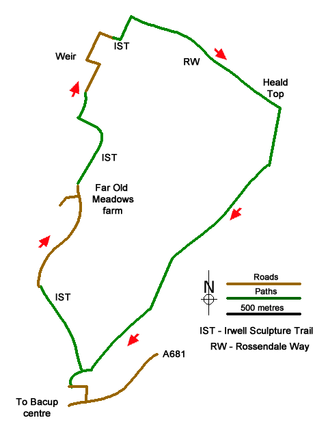
Route Map
Digital Maps - Copyright © 2011-2024. All rights reserved.
Sketch Map
Suggested Maps 

| Ordnance Survey Explorer OL21 | Sheet Map | 1:25k | BUY |
| Anquet OS Explorer OL21 | Digital Map | 1:25k | BUY |
| Ordnance Survey Digital Map Subscription | |||
| Latest Ordnance Survey Discounts | |||
It is recommended you take a map. The preferred scale is 1:25k.
Start Point Details
Ordnance Survey Grid Ref SD872234
Latitude 53.706867 Longitude -2.195384
Postcode OL13 9BL
what3words start inched.filled.announced
Walk description may contain detailed information on the start point for this walk.
Further Information
South Pennines
The South Pennines stretch from the northern boundary of the Peak District to the southern boundary of the Yorkshire Dales. Consisting of high rolling moorland, intersected by deep valleys, there is nowhere in this region that exceeds 2000 feet. The moors and valleys are where the old rivals, Lancashire and Yorkshire meet and where too the rival industries of cotton and wool. South Pennines Walking Guide
Lancashire
Lancashire offers many walking opportunities with a number of areas of high ground. The highest point is Gragareth (near Whernside) at 627 metres. The rivers drain west from the Pennines. The coast is backed by a coastal plain. Excellent areas for walking include Arnside and Silverdale National Landscape, Beacon Fell Country Park and the Forest of Bowland AONB, which includes Pendle Hill. Further south are the West Pennine Moors and the Forest of Rossendale.
Walk grading - Learn how each walk is assessed and select a walk to suit your ability and experience by going to Walk Grading Details.
Messaging & Social Media
Message Walking Britain and follow the latest news.

Mountain Weather
Stay safe on the mountains with detailed weather forecasts - for iOS devices or for Android devices.