Walk 2222 - printer friendly version
Ben Cleuch from Tillicoultry Walk
Author - Lou Johnson
Length - 7.0 miles / 11.4 km
Ascent - 2500 feet / 758 metres
Grade - moderate
Start - OS grid reference NS914974
Lat 56.156867 + Long -3.7500088
Postcode FK13 6AX (approx. location only)
The Ochil Hills or 'Ochils' can be seen across the Forth Valley and rise steeply from the valley floor. Rounded in nature, crags are few yet the range of hills offer some superb walking with great views south to Sirling, Falkirk and Edinburgh and north towards the Highlands.
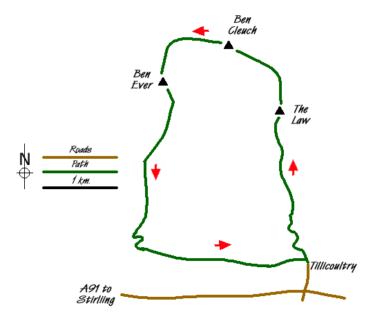
The start for this walk is Upper Mill Street (grid ref. NS914974) which can be reached from the main A91 east west road through Tillicoultry. After parking, follow the path into Mill Glen. The path starts with the stream on your left but changes sides as you make progress up the glen. Ignore any side paths and continue up stream until you arrive at the point where two deep valleys meet. These contain Daiglen (left hand valley) and Gannel Burns. Cross the wooden bridge over Gannel Burn and start the steep ascent up the nose of the Law.
The climb continues without too much relief until you have reached this minor summit with a cairn and fence. Follow the fence and clear path northwards and then veer northwest to the summit of Ben Cleuch, which for such grassy terrain seems to have more than its fair share of rocks. The view from here (on a clear day) is stupendous in a great arc from the Cairngorms to Ben Lomond.
The route of descent takes us east from the summit before turning more southerly to a col before Ben Evers. Cross the stile (grid ref. NS894005) and continue over Ben Evers and start the descent from the summit. At the first junction of paths (by a wet boggy area) bear right and continue down the clear track which now heads SSW. This descends easily to join valley track (grid ref. NS890989). Turn right and continue downhill.
The track descends in a series of loops. Look out for the footpath sign on your left (grid ref. NS890976). Take this and enter Wood Hill Wood. This wood is lovely and offers a contrast to earlier views of the walk. Reaching a picnic area continue ahead and continue through the wood.Leaving the wood you soon arrive back at the start although some careful navigation is required for the final 300 metres through houses.
Messaging & Social Media
Message Walking Britain and follow the latest news.

Mountain Weather
Stay safe on the mountains with detailed weather forecasts - for iOS devices or for Android devices.