Walk 2232 - printer friendly version
Midhurst and Woolbeding Walk
Author - Midhurst Pages
Length - 6.0 miles / 9.8 km
Ascent - 200 feet / 61 metres
Grade - easy/mod
Start - OS grid reference SU893224
Lat 50.994079 + Long -0.72892073
Postcode GU29 0AJ (approx. location only)
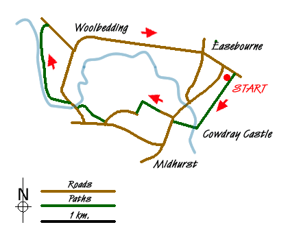
The start of this South Downs walk in West Sussex is the free car park opposite the Cowdray Farm Shop & Café at Easebourne near Midhurst. There are approximately 100 spaces in the car park. Exit the car park and follow the estate road for about three-quarters of a mile to the environs of Cowdray Castle. Turn right over the River Rother footbridge opposite the castle and follow the Castle Causeway to the entrance to North Street Car Park.
Continue to North Street and the zebra crossing and traffic lights. Cross over to Capron House, which is the Headquarters of the South Downs National Park. Turn right and follow the pavement past the new Academy school to North Bridge Weir. The Rother Path sign is near the bench situated in a small meadow. Follow the path along the river for three-quarters of a mile until you reach the National Trust Woolbeding Parkland sign and gate.
Either climb gently half left to Whiphill Wood, pass through the wood, and thence towards the A272 over rolling grassland to the public path which leads to Woolbeding Bridge or walk straight ahead along the fenceline for 400 yards, pass through a gate, and walk round Woolbeding Lake, now on your left. In front, across the river on a rise you can just see Woolbeding House and the Folly. The river curls round to the west with graceful meanders until it arrives at Woolbeding Bridge.
You need to cross the river at Woolbeding Bridge. This is on the lane from the A272 to Woolbeding. After walking round the lake pass through a gate into rolling grassland and strike uphill half left until you are above the woodland strip leading to Woolbeding Bridge. Drop down to the NT gate and join the public footpath which leads along the river to the bridge. Cross the bridge and turn left immediately into NT Woolbeding Meadow. Walk across the meadow - NT Open Access Land - pass through a 5-bar gate close to the river, and strike up right shortly after and follow the path left through Woolbeding Wood along the bluff to Brambling Farm on the lane.
Turn right into the lane and almost immediately find the steps and path into the field on the right. Follow the field edge path and take the steps down into the lane at the road junction, immediately opposite the entrance to Woolbeding House and Gardens. Take the road, Hollist Lane, and after 50 yards climb a gentle slope to the right to a stile into the field, and follow the footpath along the field margin to Hollist House some half a mile distant. The continue along the lane into Easebourne and the start of the walk.
Messaging & Social Media
Message Walking Britain and follow the latest news.

Mountain Weather
Stay safe on the mountains with detailed weather forecasts - for iOS devices or for Android devices.