Walk 2238 - printer friendly version
Thurgoland Boundary Walk Oxspring Walk
Author - Andy Chaplin
Length - 8.6 miles / 14 km
Ascent - 850 feet / 258 metres
Grade - easy/mod
Start - OS grid reference SE273022
Lat 53.5157730 + Long -1.5897651
Postcode S36 8WD (approx. location only)
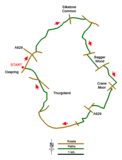
The Thurgoland Boundary Walk is just under nine miles long and takes in part of the upper Don valley as well as some of the tributaries of the river Dove. There is a short section on the old Dove Valley railway above the Silkstone tunnels and the route crosses the old Woodhead rail route twice. There is a description of things to see on the walk along with a map of the route on the Visit Penistone website. The walk itself is well signed with marker arrows almost well enough to not need a map.
Park in the lay-by at off Bower Hill in Oxspring (grid ref. SE273022) then walk up Bower Hill to the A629 and the Travellers Inn. Continue straight across on Coates Lane then turn off left at the corner and follow the Trans Pennine Trail up Maggot Lane to the railway. The Dove Valley Trail is off on the right and follows the Dove Valley line to Silkstone Common. As the tunnels are closed the path goes over the top.
Come off the trail at House Carr Lane and follow the road at the side of Nether Royd Wood in which there is the memorial to the mining disaster. Turn off right on the drive to Dodworth Moor End then immediately off right on the path that goes across fields towards Berry Moor House - which you go around to the south.
Turn left on the track to the house above Tom Royd Wood then bear left on the path down to the stream and then up through the wood to Eastfield Lane. Go right on the road then left down the drive of the first house on your left (the footpath sign is easy to miss here). The footpath crosses Bagger Wood Dike, goes through Lower Lee Wood then comes out on Bagger Wood Road next to the derelict Monkey pub.
Go left on the road until just before the Woodland Trust car park then take the path off on the right along Long Wood and towards Crane Moor. At a junction of paths go right into Crane Moor and when you come out on Hand Lane turn left then right in front of the Old Rock Inn onto Crane Moor Road.
Turn off left on the footpath just before the Methodist Church then go right and follow the path through Ayton Wood then across fields past Crane Greave. Take the path on the right past Clappers and come out again on Crane Moor Road. Walk to the junction with the A629, turn left and take the path off on the right down the fields towards the old railway line.
When you are almost at the embankment follow the path to the right, pass under the old railway line then follow the path around to the left and down to the Don. Continue along the river until you come out at the Forge Lane Bridge. A quick right and left will take you onto Old Mill lane which you follow all the way to the renovated Old Mill which is now a house. Take the path along the side of the mill pond and continue along the Don, under the railway arches then across the fields to Cheese Bottom Farm.
The track from the farm becomes the road from the water treatment plant and then it comes out on the Thurgoland Bank road near the Don bridge. Cross over and follow the path along the river - then along the pipeline - back to the Bower Hill Bridge over the Don in Oxspring.
Messaging & Social Media
Message Walking Britain and follow the latest news.

Mountain Weather
Stay safe on the mountains with detailed weather forecasts - for iOS devices or for Android devices.