Walk 2241 - printer friendly version
Gladhouse Reservoir Walk
Author - Lou Johnson
Length - 4.0 miles / 6.5 km
Ascent - 250 feet / 76 metres
Grade - easy
Start - OS grid reference NT304544
Lat 55.7778930 + Long -3.1111661
Postcode EH23 4TA (approx. location only)
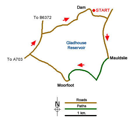
Gladhouse Reservoir is located in the Moorfoot Hills to the south of Edinburgh. The walk is easy using tracks and quiet country roads. The route follows a clockwise circuit of the Reservoir and some care is needed with navigation along the tracks to the south of the Reservoir. The reservoir is home, depending on season, to a number of birds so taking a pair of binoculars might be useful.
The start is on the north-eastern shore of the reservoir where a number of convenient parking areas are available (grid ref. NT304544). After parking walk 'clockwise' with the reservoir to your left and continue along the quiet road until it ends at Mauldslie (grid ref. NT309530). Here the road splits and you should turn right. Almost immediately take the track on your left heading across fields in a south-easterly direction. Continue along this track for just over 600 metres passing a small plantation on your left to reach a junction of tracks (grid ref. NT306524).
Turn right here and follow the clear track passing Huntly Cottage on your left (grid ref NT301526). Keep straight ahead here ignoring the track coming in from the right and continue to Moorfoot (grid ref. NT297523). Here walk through the gap between the buildings and join the lane, which heads north. After just under a mile you reach a T-junction (grid ref. NT284531). Turn right along this busier road to take the first road on your right and continue to follow this crossing the dam and your parked car.
Messaging & Social Media
Message Walking Britain and follow the latest news.

Mountain Weather
Stay safe on the mountains with detailed weather forecasts - for iOS devices or for Android devices.