Walk 2244 - printer friendly version
Whitewater Dash and Great Calva Walk
Author - Lou Johnson
Length - 7.0 miles / 11.4 km
Ascent - 1700 feet / 515 metres
Grade - moderate
Start - OS grid reference NY249323
Lat 54.6801350 + Long -3.1662780
Postcode CA12 4QX (approx. location only)
The Back o' Skiddaw offers some excellent walking and solitude. The summit of Great Calva sees few walkers and offers some fine views of the surrounding landscape including mighty Skiddaw and the Uldale Fells to the north. The route is not for inexperienced walkers and includes some pathless terrain, a steep ascent beside Dry Gill above Whitewater Dash Falls and a steep descent over rough fellside after reaching the summit of Great Calva. In poor visibility, the route could be problematic for those lacking navigational skills.
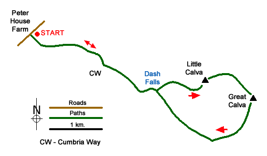
The start of this Lake District walk is the small parking area close to Peter House Farm (grid ref. NY249323) where there is space for two or three cars. After parking, head south-east on the Cumbria Way. The track rises gently and after just over a kilometre to reach a fork (grid ref. NY261319). Take the right-hand fork signed to Dash Falls. The track heads south to reach a bridge and a gate, before swinging left to run parallel to the intake wall on the northern flank of Cockup. With valley narrowing you reach Dash Falls.
A steep and rough ascent now follows on an indistinct path climbing up beside Dry Gill. Climb steeply with the fence to your left gaining height rapidly. Reaching a fence corner (grid ref. NY276315), bear right with fence to your left and follow what becomes an intermittent path initially south-east and then north-east onto the summit area of Little Calva (grid ref. NY282314). The next section onto Great Calva is boggy in places especially near the col. I took the easiest line over this section walking roughly parallel to the fence on your left to reach the summit of Great Calva with its trig point and cairns (grid ref. NY290311).
After enjoying the view descend initially from the summit cairn in a southerly direction following the fence for about 120 metres to a fence corner. There is a path, which is hard to follow in places, and I ended up continuing south for another 200 metres before veering south west towards the shallow hillside valley containing Dead Beck. After ten minutes or so I picked up the path and completed the descent to the track (grid ref. NY283303).
Turn right along the track following the Cumbria Way to Whitewater Dash. All that remains is to follow the outward route back to the start.
Messaging & Social Media
Message Walking Britain and follow the latest news.

Mountain Weather
Stay safe on the mountains with detailed weather forecasts - for iOS devices or for Android devices.