Whitewater Dash and Great Calva
Lake District Walk
Nat Park - Lake District - Lake District Northern Fells
Wainwrights - Great Calva
County/Area - Cumbria
Author - Lou Johnson
Length - 7.0 miles / 11.4 km Ascent - 1700 feet / 515 metres
Time - 5 hours 10 minutes Grade - moderate
Walk Route Description
Click image to see photo description.
The Back o' Skiddaw offers some excellent walking and solitude. The summit of Great Calva sees few walkers and offers some fine views of the surrounding landscape including mighty Skiddaw and the Uldale Fells to the north. The route is not for inexperienced walkers and includes some pathless terrain, a steep ascent beside Dry Gill above Whitewater Dash Falls and a steep descent over rough fellside after reaching the summit of Great Calva. In poor visibility, the route could be problematic for those lacking navigational skills.
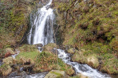
The start of this Lake District walk is the small parking area close to Peter House Farm (grid ref. NY249323) where there is space for two or three cars. After parking, head south-east on the Cumbria Way. The track rises gently and after just over a kilometre to reach a fork (grid ref. NY261319). Take the right-hand fork signed to Dash Falls. The track heads south to reach a bridge and a gate, before swinging left to run parallel to the intake wall on the northern flank of Cockup. With valley narrowing you reach Dash Falls.
A steep and rough ascent now follows on an indistinct path climbing up beside Dry Gill. Climb steeply with the fence to your left gaining height rapidly. Reaching a fence corner (grid ref. NY276315), bear right with fence to your left and follow what becomes an intermittent path initially south-east and then north-east onto the summit area of Little Calva (grid ref. NY282314). The next section onto Great Calva is boggy in places especially near the col. I took the easiest line over this section walking roughly parallel to the fence on your left to reach the summit of Great Calva with its trig point and cairns (grid ref. NY290311).
After enjoying the view descend initially from the summit cairn in a southerly direction following the fence for about 120 metres to a fence corner. There is a path, which is hard to follow in places, and I ended up continuing south for another 200 metres before veering south west towards the shallow hillside valley containing Dead Beck. After ten minutes or so I picked up the path and completed the descent to the track (grid ref. NY283303).
Turn right along the track following the Cumbria Way to Whitewater Dash. All that remains is to follow the outward route back to the start.
Maps 

| Ordnance Survey Explorer OL4 | Sheet Map | 1:25k | BUY |
| Anquet OS Explorer OL4 | Digital Map | 1:25k | BUY |
| Ordnance Survey Digital Map Subscription | |||
| Latest Ordnance Survey Discounts | |||
Other walks nearby
| Walk 1676 | Ullock Pike, Long Side and Carl Side | moderate | 5.5 miles |
| Walk 2040 | Ullock Pike & Carlside | moderate | 5.5 miles |
| Walk 1177 | Great Sca Fell via Trusmadoor | moderate | 6.5 miles |
| Walk 3283 | Great Cockup and Meal Fell from Longlands | moderate | 6.0 miles |
| Walk 2041 | Barf (via the Bishop) and Lords Seat | mod/hard | 4.0 miles |
| Walk 2612 | Roughton Gill, Caldbeck Fells | easy | 4.5 miles |
| Walk 2390 | High Pike from Fell Side | moderate | 5.2 miles |
| Walk 1073 | Skiddaw & Glenderaterra Beck | moderate | 9.0 miles |
| Walk 1244 | Lonscale Fell & Latrigg | moderate | 7.5 miles |
| Walk 1120 | Grisedale Pike & Crag Hill fro Braithwaite | mod/hard | 8.5 miles |
Recommended Books & eBooks
Walking the Lake District Fells - Wasdale
 Part of the Walking the Lake District Fells series, this guidebook covers a wide range of routes to 25 Lakeland summits that can be climbed from the Wasdale, Eskdale and Ennerdale valleys, with highlights including Scafell Pike, Great Gable and Pillar. Suggestions for longer ridge routes are also included.
More information
Great Mountain Days in the Lake District
 An inspirational guidebook to 50 challenging walks on the high fells of the Lake District. The graded circular routes, between 4 and 14 miles in length, cover classic Lakeland summits like Fairfield, Scafell Pike, Great Gable and Blencathra, to the lesser-known High Spy, King's How and Brund Fell.
More information
