Tittleshall, Mileham & Godwick
Norfolk Walk
County/Area - Norfolk
Author - Lou Johnson
Length - 7.0 miles / 11.4 km Ascent - 300 feet / 91 metres
Time - 3 hours 50 minutes Grade - easy/mod
Walk Route Description
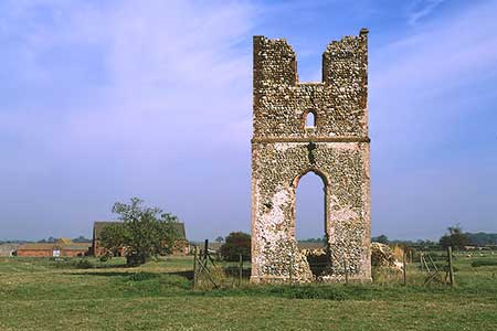
Click image to see photo description.
An interesting walk from Tittleshall (Norfolk) that includes the remains of a castle at Mileham and the deserted village of Godwick. Thew route follows field paths across farmland which is dotted with areas of woodland. In addition, the parish churches at Tittleshall and Mileham are worth a visit.
The start is the Millennium Green car park on Church Lane in Tittleshall (grid ref. TF894211). Exit the car park and turn left along Church Lane. When the lane bends left, take the footpath ahead. The path goes right along the field edge into another field and then heads half-left across the field to reach a lane. Turn left, follow the lane around a left-hand bend and take the first signed footpath on the right (grid ref. TF896207).
Follow the enclosed path until it ends in a field after 800 metres. Turn left to join the Nar Valley Way. The path heads diagonally across the field to the far left-hand corner. The path continues across the next field passing to the left of an island of trees to the far left-hand corner. Cross a footbridge and turn right along a track and follow this to reach Back Lane in Mileham. Turn left and continue to the B1145 (The Street). Turn left and continue past the village hall on your left. Just opposite are the remains of Mileham Castle with a gate for access. Stay on the B1145 for a further kilometre passing St John's Church on your right (worth a visit). Immediately after passing the end of 30 mph speed limit, turn left onto a unsigned grassy path (grid ref. TF925199).
Go through a gate and stay on the path until you reach a small wood on your right. Cross the stile on the right and then head across the middle of the next field aiming just to the left of a small wood. At the end of the trees turn right and then left. Continue with a hedge on your right to Stanfield Road (grid ref. TF917210). Turn right and then take the first signed path on the left. The path runs parallel but not adjacent to the field boundary on your left. Continue the end of the field. Turn left to a small footbridge leading into the woodland. Fork right and continue to the far corner of the Fox Covert. Continue across a field keeping to the left of a small wood. Maintain direction across the field to the hedge at the far end. Turn right along the hedge and follow waymarked path through trees.
Reaching a path junction (grid ref. TF915229), turn sharp left and follow the path which runs diagonally across six fields to pass Godwick Farm on your right (grid ref. TF906223). Cross an access drive and continue past the remains of Godwick Church on your left. There is a permissive path to the ruins. Continuing along the waymarked path, pass through a kissing gate and follow the path half-left across a field. Pass through a gap and continue diagonally across the next field to reach Church Lane in Tittleshall. Turn left back to the start.
Maps 

| Ordnance Survey Explorer 238 | Sheet Map | 1:25k | BUY |
| Anquet OS Explorer 238 | Digital Map | 1:25k | BUY |
| Ordnance Survey Digital Map Subscription | |||
| Latest Ordnance Survey Discounts | |||
Other walks nearby
| Walk 2436 | The Nar Valley from Castle Acre | easy | 6.1 miles |
| Walk 3256 | Great Bircham & Fring Circular | easy/mod | 8.4 miles |
| Walk 1035 | Burnham Market | easy | 5.5 miles |
| Walk 1908 | Wells-next-the-Sea & Holkham Park | easy/mod | 8.0 miles |
| Walk 2101 | Holkham Park circular | easy | 4.5 miles |
| Walk 3254 | Holkham & Holkham Park Circular | moderate | 10.2 miles |
| Walk 2081 | Holkham Gap and West Beach from Wells-next-the-Sea | easy | 4.0 miles |
| Walk 2127 | The Brecks from near Thompson | easy | 6.8 miles |
| Walk 1600 | Morston Salt Marshes from Morston Quay | easy | 2.5 miles |
| Walk 2307 | Blakeney from Morston Quay | easy | 2.0 miles |
