Walk 2263 - printer friendly version
Grindon & the Manifold Way from Waterhouses Walk
Author - Lou Johnson
Length - 8.0 miles / 13 km
Ascent - 1200 feet / 364 metres
Grade - moderate
Start - OS grid reference SK085501
Lat 53.048097 + Long -1.8746565
Postcode ST10 3JS (approx. location only)
This Peak District walk combines field paths, quiet lanes and the Manifold Way to explore the Staffordshire countryside in the southern sector of the National Park. Limestone is the predominant rock but in the distance you can see the gritstone hills of the Staffordshire Moorland. The geology goes a long way to explaining why the River Hamps (followed on the return part of the route) is usually dry. The pictures were taken after a particularly wet July (2007) so the water in the river is remarkably high and running at very unusual levels.
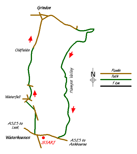
The start is the small pay and display car park adjacent to the Cycle Hire (Grid ref. SK085501) centre in Waterhouses. This is accessed via a tarmac drive on the south side of the disused railway bridge over the road to Cauldon Low. After parking walk back down the approach drive and veer right down the access path to reach the main road. Turn left towards Leek along the A523. After approximately 100 metres, take the signed footpath on the north side of the road (Grid ref. SK083502). This leads across fields to reach Rocester Lane. Turn left and walk towards Waterfall. After just over 100 metres, take the signed path on your left and cross field to reach the road in the village of Waterfall.
Take the drive leading north between houses from the main road junction. The drive leads into a footpath, which soon passes the church. Just past church bear slightly left and continue on the path, descending to a footbridge and a lane (Grid ref. SK081519). Cross over and go slightly left to locate a dilapidated stile and a half hidden sign. Cross this stile and follow the farm track into the farm yard. Immediately after entering the yard, turn left and go through the gate and walk uphill with the field boundary to your immediate left. This leads to Slade Lane.
Turn left on this one time an important pack-horse route to reach Oldfields Farm. Go through the yard and continue along the metalled access road past Deepdale Farm towards the village of Grindon with an impressive church and tall spire. At the first road junction (Grid ref. SK885542) turn right towards Weag's Bridge and Wetton. You could spend a few minutes exploring the village and its church, after which you should return to this junction to continue the walk. Follow the lane towards the Manifold Valley as far as a sharp left hand bend (Grid ref. SK097539). Here you leave the road and take the bridle path that goes straight on. This descends to reach light woodland before reaching the Manifold Way on the valley floor.
Turn right along the Manifold Way, which is shared by walkers, horse-riders and cyclists. Originally the trackbed of the narrow-gauge Leek and Manfold Light Railway, the route lay abandoned for many years after the closure of the railway between the Wars. Following the normally dry bed of the Hamps, the surfaced trail climbs gently back to the main A523 near Waterhouses. The trail follows the valley, which is wooded for the first section but eventually becomes flanked by hillside pastures. Reaching the main road, turn right and continue towards the centre of Waterhouses. On your left you will reach a path leading between metal barriers back to the car park.
Messaging & Social Media
Message Walking Britain and follow the latest news.

Mountain Weather
Stay safe on the mountains with detailed weather forecasts - for iOS devices or for Android devices.