Walk 2265 - printer friendly version
Semer Water, Stalling Busk & Marsett Walk
Author - Lou Johnson
Length - 4.0 miles / 6.5 km
Ascent - 400 feet / 121 metres
Grade - easy
Start - OS grid reference SD922875
Lat 54.2830740 + Long -2.1213064
Postcode DL8 3DD (approx. location only)
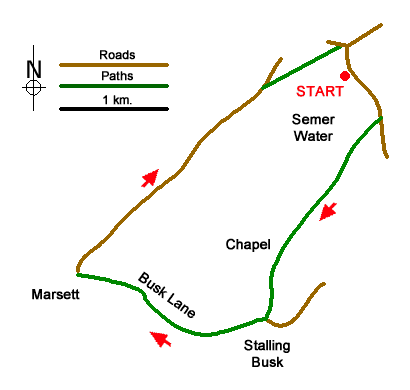
Starting from the shores Semer Water, this walk explores the farming communities of Stalling Busk and Marsett. The route uses field paths, Busk Lane, and short section of lane. Along the way the walk passes a ruined chapel and enjoys views across Semer Water and the surrounding countryside. This walk can be combined with Walk 3524 from Bainbridge.
The start is a parking area by the shore of Semer Water (grid ref. SD922875). Like Malham Tarn, this is a natural lake formed in a side valley off Wensleydale. After parking, face the lane and turn right. Continue along the lane to Low Blean Farm and turn right at the fingerpost through a gate. You are now following the Pennine Journey long distance path for the first section of the walk. The path crosses several stiles to reach the lake shore. A further series of stiles leads past the ruined chapel of Stalling Busk on your right. Just after the chapel ruins fork left and follow the beck which leads you into the hamlet of Stalling Busk (grid ref. SD916859).
Just after the Church of St. Matthew on the left, turn right along a rough track, Busk Lane. Continue along the enclosed track to reach a ford over Cragdale Water. If the water is high, bear right before the beck and cross using a footbridge. Continue along the track, using the footbridge on the left to cross Raydale Beck. Continue into Marsett. Just past the first building on the left, veer right across grass to cross Marsett Bridge (grid ref. SD903862). Follow the lane for about 1.5 kilometres enjoying a view across the lake and ahead to shapely Addlebrough (hill). Take the first footpath on the right by a finger post with a yellow top. Cross the stile and bear half left along a path that crosses fields to reach a lane by Semer Water Bridge. Turn right across the bridge back to the start.
Messaging & Social Media
Message Walking Britain and follow the latest news.

Mountain Weather
Stay safe on the mountains with detailed weather forecasts - for iOS devices or for Android devices.