Walk 2266 - printer friendly version
Westbury White Horse Circular Walk
Author - Lou Johnson
Length - 3.6 miles / 5.9 km
Ascent - 500 feet / 152 metres
Grade - easy
Start - OS grid reference ST885516
Lat 51.2634390 + Long -2.1662025
Postcode BA13 4TQ (approx. location only)
A short walk visiting the Westbury White Horse. Dating from 1772 it is the oldest white horse in Wiltshire. The route uses bridleways, quiet lanes, and footpaths to vies the horse from the countryside before climbing the escarpment for a closer view.
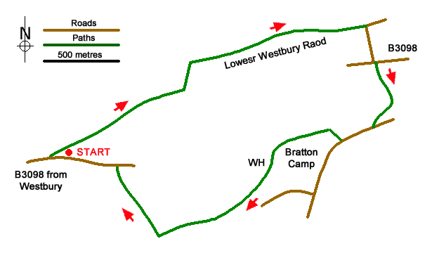
The route starts from the car park at Westbury White Horse viewpoint (grid ref. ST885516) a few kilometres west of Westbury on the north side of the B3098. After parking, exit onto the B3098 and turn right. Almost immediately turn sharp right along a signed bridleway to follow Lower Westbury Road through pleasant countryside. The view on the right includes the White Horse carved in the face of Bratton Down. After a kilometre the lane bends left and shortly after turns right. Continue for another kilometre or so to a junction (grid ref. ST909525). Turn right signed to Westbury.
Continue along the lane to the B3098., Cross the road and take the signed footpath opposite. Initially the path runs along the left-hand edge of a field but as you gain height the path is enclosed between hedges and leads through a kissing gate onto a lane (grid ref. ST905518). Turn right uphill and after 240 metres bear right off the road up to a gate and adjacent stile. Once over the stile turn right and follow a clear path to the edge of the escarpment and then turn left. Follow the clear path along the edge to pass above the White Horse cut in the escarpment below you. Continue a short distance to a wooden kissing gate (grid ref. ST899515).
Pass through the kissing gate, climb the steps and follow a grassy path to a bench, with adjacent information board, from where there is an excellent view back to the White Horse. After enjoying the view continue along the grassy path to a path junction with a descending bridleway between trees. Keep ahead here and follow the path with a fence on your right. After 500 metres you pass through a fence lined with small trees on your right. Continue ahead to a small wood and turn right (grid ref. ST891511) to join a descending path. Note there is a network of paths heading downhill. As you descend aim to the right of Town Farm. At the farm join their access drive to the B3098 and turn left. The car park is 300 metres along the road on the right.
Messaging & Social Media
Message Walking Britain and follow the latest news.

Mountain Weather
Stay safe on the mountains with detailed weather forecasts - for iOS devices or for Android devices.