Walk 2267 - printer friendly version
Godrevy Point & Hell's Mouth Walk
Author - Lou Johnson
Length - 5.2 miles / 8.5 km
Ascent - 800 feet / 242 metres
Grade - easy/mod
Start - OS grid reference SW584422
Lat 50.2303240 + Long -5.3889607
Postcode TR27 5ED (approx. location only)
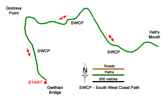
This beautiful walk between Godrevy Point and Hell's Mouth includes a section of rugged North Cornwall Coast and is ideal for a family outing. The route is easy to follow using a section of the South West Coast Path and includes Godrevy Island with its lighthouse, views across St. Ives Bay and the chance to see seals and dolphins. Along the way there are small coves and beaches where you may wish to linger a while.
The start is the Godrevy National Trust car park (grid ref. SW584422) which is signed off the B3301 Hayle to Portreath road (brown sign). Follow the access road off the B3301 and use the first car park on the left which has a café. After parking walk to the end of the car park (sea on your left), pass the surf school, and follow a clear path. Pass a small parking area on your right and where the road bends right, leave the road and fork left along a grassy path. Just up the road you can see a toilet block and another car park. The path runs above Godrevy Cove with its sandy beach. Ignore the path down to the beach and bear right to continue along the cliff tops. Pass through a stone wall and enjoy the view to Godrevy Island with its lighthouse, which was built in 1854 after a number of ships were wrecked on the rocks.
Soon after passing the lighthouse, the path bends right and the view ahead includes a fine stretch of North Cornwall coast. The next cove on the left (Mutton Cove) often has seals basking on the shore. The onward undulating path is easy to follow and continues along the cliff tops to reach a gate (grid ref. SW589433) which provides access to the heathland of the Knavocks. Continue along the coast path rounding another headland (Navax Point). A short diversion up to the OS trig column offers a wider view and is the highest point of walk (76 m., 237 ft.).
From here the path continues along the cliffs. Continue ahead and follow the path along the cliff tops gradually descending to Hell's Mouth. This is a dramatic, rocky inlet and one can imagine how it got its name. Close by on the roadside is a café if you need refreshments. To return to the start, retrace your steps along the South West Coast Path enjoying a different perspective of this rugged coast.
Messaging & Social Media
Message Walking Britain and follow the latest news.

Mountain Weather
Stay safe on the mountains with detailed weather forecasts - for iOS devices or for Android devices.