Godrevy Point & Hell's Mouth
Cornwall AONB Walk
Region - Cornwall AONB
County/Area - Cornwall
Author - Lou Johnson
Length - 5.2 miles / 8.5 km Ascent - 800 feet / 242 metres
Time - 3 hours 20 minutes Grade - easy/mod
Walk Route Description
Click image to see photo description.
This beautiful walk between Godrevy Point and Hell's Mouth includes a section of rugged North Cornwall Coast and is ideal for a family outing. The route is easy to follow using a section of the South West Coast Path and includes Godrevy Island with its lighthouse, views across St. Ives Bay and the chance to see seals and dolphins. Along the way there are small coves and beaches where you may wish to linger a while.
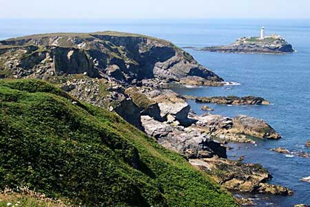
The start is the Godrevy National Trust car park (grid ref. SW584422) which is signed off the B3301 Hayle to Portreath road (brown sign). Follow the access road off the B3301 and use the first car park on the left which has a café. After parking walk to the end of the car park (sea on your left), pass the surf school, and follow a clear path. Pass a small parking area on your right and where the road bends right, leave the road and fork left along a grassy path. Just up the road you can see a toilet block and another car park. The path runs above Godrevy Cove with its sandy beach. Ignore the path down to the beach and bear right to continue along the cliff tops. Pass through a stone wall and enjoy the view to Godrevy Island with its lighthouse, which was built in 1854 after a number of ships were wrecked on the rocks.
Soon after passing the lighthouse, the path bends right and the view ahead includes a fine stretch of North Cornwall coast. The next cove on the left (Mutton Cove) often has seals basking on the shore. The onward undulating path is easy to follow and continues along the cliff tops to reach a gate (grid ref. SW589433) which provides access to the heathland of the Knavocks. Continue along the coast path rounding another headland (Navax Point). A short diversion up to the OS trig column offers a wider view and is the highest point of walk (76 m., 237 ft.).
From here the path continues along the cliffs. Continue ahead and follow the path along the cliff tops gradually descending to Hell's Mouth. This is a dramatic, rocky inlet and one can imagine how it got its name. Close by on the roadside is a café if you need refreshments. To return to the start, retrace your steps along the South West Coast Path enjoying a different perspective of this rugged coast.
Maps 

| Ordnance Survey Explorer 102 | Sheet Map | 1:25k | BUY |
| Anquet OS Explorer 102 | Digital Map | 1:25k | BUY |
| Ordnance Survey Digital Map Subscription | |||
| Latest Ordnance Survey Discounts | |||
Other walks nearby
| Walk 2206 | St. Ives - a town stroll | easy | 1.5 miles |
| Walk 2294 | St. Agnes to Porthtowan | easy/mod | 5.0 miles |
| Walk 2208 | Marazion - a town stroll | easy | 1.0 miles |
| Walk 1081 | Zennor & St Ives coast path | mod/hard | 11.0 miles |
| Walk 1223 | Morvah to Zennor coast | moderate | 5.5 miles |
| Walk 2207 | Penzance - a town stroll | easy | 1.5 miles |
| Walk 3501 | Penzance to Porthcurno via Mousehole and Lamorna | moderate | 11.0 miles |
| Walk 2205 | Newlyn - a village trail | easy | 1.0 miles |
| Walk 1224 | Men-an-tol & Ding Dong Mine | easy | 3.0 miles |
| Walk 3325 | Chun Quoit & Carn Kenidjack | easy | 4.0 miles |
Recommended Books & eBooks
Walking in Cornwall
 This guidebook includes routes to 40 day walks in Cornwall. From short, easy strolls to longer, wilder routes, there is plenty to appeal to both families and experienced walkers. The walks explore the interior and coasts, including walks through picturesque villages, old tin-mining areas and the Lizard and Land's End Peninsulas.
More information
The South West Coast Path
 Guidebook to walking the entire South West Coast Path National Trail. The route runs for 630 miles from Minehead to Poole along the north Devon, Cornish, south Devon and Dorset coastline. Divided into 45 stages, this long-distance coastal trek could be completed within 4 weeks, or walked in sections. Guide includes maps and essential information.
More information
