Walk 2279 - printer friendly version
Salcombe Regis & Weston Mouth Walk
Author - Lou Johnson
Length - 5.1 miles / 8.3 km
Ascent - 1300 feet / 394 metres
Grade - easy/mod
Start - OS grid reference SY139882
Lat 50.6870580 + Long -3.2201922
Postcode EX10 0NY (approx. location only)
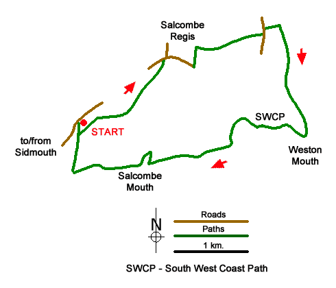
Starting from near Sidmouth this walk explores countryside and coast. The route includes the village of Salcombe Regis and its parish church, the Donkey Sanctuary near Weston, and a dramatic section of the South Devon coast following the South West Coast Path. Note there are some steep climbs and descents.
The walk starts from the National Trust Sidmouth Countryside pay and display car park (grid ref. SY139882). After parking, face the rear of the parking area and join the track running along the left-hand side. Just before reaching open countryside, turn left along a path that runs just inside woodland with barns on your right. Go straight ahead at the first two path junctions. At the third junction go straight across to join a descending track through trees. At the bottom, bear left along a track. The track soon joins a lane which is followed into Salcombe Regis. St. Mary and St. Peter's church on the right is worth a visit if time permits.
Just past the church, turn right into the village and take the first lane on the right. The line climbs out of the village. Ignore the first footpath on the left and continue to the next signed path on the left (partly hidden in dense hedge). Follow the grassy path to far-right hand corner of the field and turn right. Keep to the left-hand side of three fields. The path turns left and then almost immediately right and continues to a road (grid ref. SY159892). Turn left and at the mini-roundabout turn right into the Donkey Sanctuary. Walk past the paddocks on your right and keep to the right of the restaurant to a signed path junction. Turn right and follow the path as it descends nearer to the sea at Weston Mouth.
Turn right along the South West Coast Path. The path climbs steeply over Lower Dunscombe Cliff heading inland to walk around the hanging valley of Lincombe. The path returns to the sea and crosses Lower Dunscombe Cliff. Reaching Salcombe Mouth the path briefly turns inland around a deep ravine before continuing close to the cliff top. A final steep climb to the top of the cliffs from where an extensive view can be enjoyed. The path starts to descend. Take the next clear path on the right to return to the car park.
Messaging & Social Media
Message Walking Britain and follow the latest news.

Mountain Weather
Stay safe on the mountains with detailed weather forecasts - for iOS devices or for Android devices.