Walk 2285 - printer friendly version
Llyn Geirionydd & Llyn Crafnant Walk
Author - Lou Johnson
Length - 5.5 miles / 8.9 km
Ascent - 1100 feet / 333 metres
Grade - easy/mod
Start - OS grid reference SH763605
Lat 53.1272700 + Long -3.8501620
Postcode LL27 0YX (approx. location only)
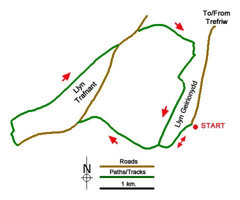
A beautiful walk featuring two lakes in the Carneddau mountains. The route starts from the shores of Llyn Geirionydd and climbs across ridge to Llyn Crafnant. The shore of this reservoir is followed before recrossing the ridge to complete the walk with a walk along the shores of Llyn Geirionydd.
The start is the car park and picnic area at the south end of Llyn Geirionydd (grid ref. SH763605), after parking walk towards the lake and turn left. Continue along the road to where it bends sharp left and turn right along a track. Follow the track as it bends to the left and after 200 metres turn right off the track to join a narrow path climbing steeply up through the forest. The path crosses the track twice before joining another track. Where this track bends sharp right, continue ahead a narrow rising path. You soon reach the crest of the ridge where there is a great view to Moel Siabod and the Conwy Valley. Follow the descending path, cross a stile, and enjoy a good view of Llyn Crafnant. Continue descending, cross another ladder stile on the left and drop down to the lane beside Llyn Crafnant.
Turn left and follow the lane to a gate. Pass through the gate and turn right along a track. Go through another gate, and immediately turn right over a small footbridge. After another gate the route is waymarked with yellow topped marker posts through the forest to a ladder stile. Reaching the next marker post, turn right along a track and which soon reaches a forest track close to the lake Continue ahead along this track to reach a monument and a road.
Turn left along the road and continue for 500 metres to where a forest track forks right (near the car park on the left). Continue along this track to a sharp right-hand bend and take the path on the left. Cross a stile to pass old mine workings on your right. Note these mine workings are not safe for exploration. Reaching a fork in the path, go right and continue through a wall gap, pass through woodland, and over a ladder stile. About 90 metres from the ladder stile, turn right at a path junction to follow a grassy track. Shortly after you have a view of Llyn Geirionydd. Continue to a large cairn, drop down to a stile by the lake. Cross the stile and turn right and follow the lakeside path/track back to the southern end of the lake. Turn left and return to the parking area.
Messaging & Social Media
Message Walking Britain and follow the latest news.

Mountain Weather
Stay safe on the mountains with detailed weather forecasts - for iOS devices or for Android devices.