Walk 2303 - printer friendly version
Holme Fen Circular Walk
Author - Barry Mackie
Length - 3.1 miles / 5 km
Ascent - 10 feet / 3 metres
Grade - easy
Start - OS grid reference TL212881
Lat 52.477379 + Long -0.21689981
Postcode PE7 3PP (approx. location only)
Virtually unique to the low lying East Anglian region of the country, fenland walking offers a somewhat different way of enjoying the British countryside. With their carefully managed series of drainage ditches and fertile soils, the fens host a diverse species of flora and fauna that readily flourish in this lush environment.
Much of this is available to see for the casual walker, and some of the fens have well established hides where you can possibly get better views, particularly of the various species of birds that inhabit the wetlands. Holme Fen has all this and a walk around makes for an enjoyable stroll, but this place has even more to offer.
To contain the largest concentration of silver birch trees in the lowlands is interesting enough, but the main attraction to Holme Fen is that this is also the lowest land (i.e. place where you can walk with the sun and wind in your face) in all of Britain. At the site of the Holme Fen Posts (visited during this walk) plenty of facts and figures are provided as to why and how this is so. There are plenty of different options to explore the fen and this is the one we chose.
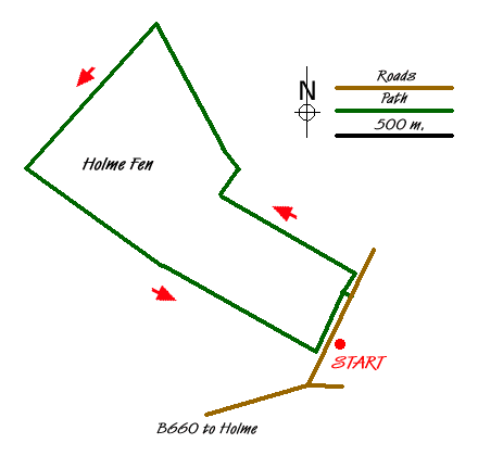
Holme Fen can be reached by leaving the A1(M) at junction 15 or 16, depending on which direction you are travelling. Head for the village of Holme and pass it to go west on the B660. Turn first left (grid ref. TL212881) and park on the minor road
Cross the ditch that runs parallel to the road via the wooden foot bridge (grid ref. TL214885) to soon head in a general Northwest direction, but first note the board alongside the entrance that shows the network of paths and the location of the hides and Posts. Follow the wide and well maintained path/ride through the woodlands and glades, which as previously mentioned are predominantly silver birches, to turn right at the junction (grid ref. TL 208889).
Here continue Northeast for a short distance to then turn North/northwest, but rather than keep going and then come out of the fen at the road, we turned left at the fork (grid ref TL206894) and headed southwest so we could extend our stay in the fen. At the junction (grid ref. TL 201 890) turn right to soon leave the woodland and onto the grassed edge alongside a wide flooded ditch that is parallel to a road on the far side. I say "ditch" simply because a look at the OS Explorer describes this as the "Holme Fen Engine Drain", and that is no name for a river! Also whilst you are standing here you might notice that the OS map is giving a spot height of 2 metres below sea level, which as the drain you are looking at has still some 50kms to go before it gets to the sea, the "Engine" is very applicable. In these parts the rivers have to be pumped to help them on their way.
Facing the drain, turn right to walk up the slightest of inclines towards the visible footbridge to reach the Holme Fen Posts on the right at the edge of the woods. A very useful information board situated between the posts tells as much as you need to know. Briefly, the posts, especially the right hand one, have recorded the continual sinking of the surrounding land since the area was drained some 160 years ago. The board also states this is the lowest place in Britain at some 2.7 m below sea level. Absolutely fascinating, we thoroughly enjoyed all this!
Leave here and retrace your steps back down the slope to turn left into the fen at what was your recent exit point, to follow the track in a south easterly direction until you are alongside the road you parked on. Turn left and walk alongside the ditch parallel to the road to cross at the wooden bridge and return to your car. This last section alongside the edge of the fen really does sum up the charms of this part of the country. The views across the flat countryside open up in front of you and as always in the distance; you can just make out some hills. OK, and so what that they are probably over the border into an adjacent county. Given what we had just seen, somehow it really did not matter at all.
Notes - As always, come prepared and correctly kitted out, but you may think that this walk would be at least a bit boggy underfoot. Not so when we did it during a very wet spell in 2008, the paths were dry throughout the whole trip. Holme Fen is owned and managed by English Nature and is open to the public. You are requested to keep to the well defined and maintained paths (rides). Free parking is available along the road where we entered the fen, with no restrictions. There are no public toilets or refreshments facilities within the immediate area.
Messaging & Social Media
Message Walking Britain and follow the latest news.

Mountain Weather
Stay safe on the mountains with detailed weather forecasts - for iOS devices or for Android devices.