Bladon & Begbroke Circular
Oxfordshire Walk
County/Area - Oxfordshire
Author - Lou Johnson
Length - 5.0 miles / 8.1 km Ascent - 250 feet / 76 metres
Time - 2 hours 50 minutes Grade - easy
Maps 

| Ordnance Survey Explorer 180 | Sheet Map | 1:25k | BUY |
| Anquet OS Explorer 180 | Digital Map | 1:25k | BUY |
| Ordnance Survey Landranger 164 | Sheet Map | 1:50k | BUY |
| Anquet OS Landranger 164 | Digital Map | 1:50k | BUY |
Walk Route Description
Click image to see photo description.
Starting from the village of Begbroke lying a few miles to the north of Oxford on the A44 this walk captures many of the features typical of the county's scenery. The start is close to the parish church on the west side of the main road and accessed from the roundabout in the village centre (grid ref. SP468138) where limited on street parking is available. Please make sure you park considerately.
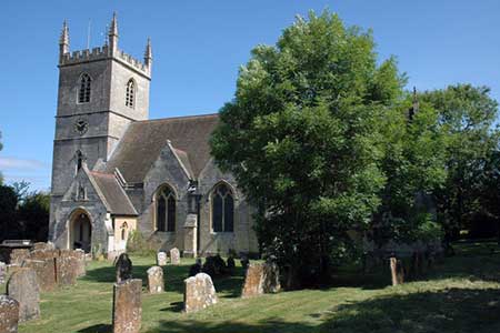
After parking, walk west away from the main road along Spring Hill Road. Follow the road as it turns left, right and then left again to reach a track (grid ref. SP465136) on your right. Take this and continue past Hall Farm (on your left). You are now on Shakespeare's Way. Follow this clear path as it crosses fields before entering woodland of Bladon Heath. The path continues through the woods and emerges into open heathland before reaching houses. Do not take the tarmac road ahead instead turn right down the signed footpath (grid ref. SP452144). This path passes a small wood on your left (Withy Clump) to reach a cross path at grid ref. SP454148. Turn left here and continue into Bladon passing Winston Churchill's grave in churchyard of St Martin's on your left.
Walk through the churchyard and take the southern exit (grid ref. SP448148). Continue straight ahead along Church Street to reach a crossroads with Lamb Lane. Go straight across into Manor Road. Follow this road as it bears right and then turns left. Continue to where Manor Road bears ton the right and take the footpath on your left (grid ref. SP446145). Follow this path across a field with the field boundary to your right. Go into the next field and after 200 metres follow the path as it turns sharp right to cross a further field to reach a road (grid ref. SP445138).
Turn left along the road to Burleigh Lodge. The onward path initially skirts woodland to your left before going half left across the second field. Continue across more fields reaching a path junction in just over a mile from Burleigh Lodge at Spring Hill (grid ref. SP463127). Turn left here onto Shakespeare's Way and continue onto a well-made track. Follow this track as it heads towards Begbroke. The track bears left and soon joins Spring Hill Road and the point where your initially joined Shakespeare's Way (grid ref. SP465136). Continue ahead along Spring Hill Way and you will soon be back at the start.
Other walks nearby
| Walk 3357 | Blenheim Palace Great Park | easy | 6.6 miles |
| Walk 3456 | Swinford Bridge from Lower Wolvercote | easy/mod | 7.0 miles |
| Walk 2687 | Chadlington Circular | easy/mod | 6.3 miles |
| Walk 3728 | Ledwell & Nether Worton from Great Tew | easy/mod | 6.4 miles |
| Walk 2628 | Charndon & Edgcott | easy | 6.0 miles |
| Walk 1062 | Pusey & Buckland circular | easy | 3.5 miles |
| Walk 1439 | Fulbrook & Widford | easy | 6.0 miles |
| Walk 2186 | Adlestrop & Chastleton | easy | 3.8 miles |
| Walk 2076 | Kingham to Charlbury | easy/mod | 10.5 miles |
| Walk 2396 | Finmere & Westbury | easy/mod | 6.1 miles |
Recommended Books & eBooks
No suggestions for this area.Messaging & Social Media
Message Walking Britain and follow the latest news.

Mountain Weather
Stay safe on the mountains with detailed weather forecasts - for iOS devices or for Android devices.