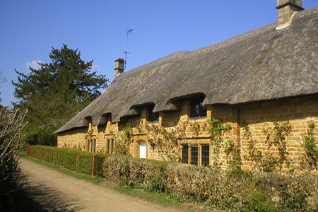
Ledwell & Nether Worton from Great Tew
Cotswolds Walk
Region - Cotswolds
County/Area - Oxfordshire
Author - Lou Johnson
Length - 6.4 miles / 10.4 km Ascent - 420 feet / 127 metres
Time - 3 hours 40 minutes Grade - easy/mod
Walk Route Description
Click image to see photo description.
A lovely Cotswolds circular walk from the charming village of Great Tew with its thatched cottages built from mellow stone. The route crosses pleasant countryside to reach Ledwell. Turning north the walk continues via Over Worton and Nether Worton before returning to the start along a green lane.
The start is village car park in Great Tew (grid ref. SP395293). After parking, exit the car park and turn left. Continue just past the Falkland Arms and turn left onto the signed bridleway to Ledwell. Continue along the clear track for just over a kilometre keeping the hedge to your right. The bridleway now bears right through a gate with a blue arrow way marker (grid ref. SP408294). Follow the grassy track keeping the hedge to your right and continue to Hobbshole Farm. Keeping the majority of the farm buildings to your left continue ahead to join the farm's access driveway and continue to a road (grid ref. SP413284).
Turn left and continue into Ledwell following the road as it bends right. Just past Manor Farmhouse turn left passing a row of cottages on the left to reach the well (grid ref. SP420282). Bear left at the fingerpost signed Over Worton and keep to the left of a fence across a lawn. Turn right at the wall and continue for 140 metres to pass through a gate (grid ref. SP421282). Once through the gate go half left across fields and Cockley Brook to reach a stile and a road (grid ref. SP426286).
Turn right along the road. After 120 metres turn left at the fingerpost signed to Over Worton. Continue up the drive to Grange Farm (grid ref. SP427289). Keep the farm on your left and bear right on path through a gap in the hedge. Go half right across the first field and maintain direction across the next field to a stile to reach a lane in Over Worton (grid ref. SP430291). Turn left and then bear right to Holy Trinity Church. Walk through the churchyard keeping the church on your left. Exit the church grounds and follow a footpath heading roughly north across fields to Nether Worton (grid ref SP426301).
Turn left past St James Church to a road junction. Go left along the road to Ledwell. Follow the road for 400 metres to a sharp left-hand bend. 50 metres after the bend, turn right along a bridleway at the fingerpost on the right. Continue for 350 metres and follow the path half left across a field to re-join the bridleway. Continue north across the next field to reach a junction of tracks (grid ref. SP415305). Turn left and follow Groveash Lane (track) and continue for 1.2 kilometres to a T-junction (grid ref. SP402302). Turn left and continue for 600 metres to bear left past Park Farm to return to Great Tew and the start.
Maps 

| Ordnance Survey Explorer 191 | Sheet Map | 1:25k | BUY |
| Anquet OS Explorer 191 | Digital Map | 1:25k | BUY |
| Ordnance Survey Digital Map Subscription | |||
| Latest Ordnance Survey Discounts | |||
Other walks nearby
| Walk 1981 | Epwell from Sibford Gower | easy/mod | 5.6 miles |
| Walk 2687 | Chadlington Circular | easy/mod | 6.3 miles |
| Walk 1971 | Gallow Hill, Epwell & Swalcliffe | easy/mod | 7.8 miles |
| Walk 2186 | Adlestrop & Chastleton | easy | 3.8 miles |
| Walk 3357 | Blenheim Palace Great Park | easy | 6.6 miles |
| Walk 2489 | Upper Brailes Circular | easy/mod | 5.6 miles |
| Walk 2076 | Kingham to Charlbury | easy/mod | 10.5 miles |
| Walk 3042 | Thenford Hill & Upper Wardington from Middleton Cheney | easy/mod | 7.5 miles |
| Walk 3222 | Edge Hill and Upton House | easy/mod | 6.5 miles |
| Walk 2322 | Bladon & Begbroke Circular | easy | 5.0 miles |
Recommended Books & eBooks
The Cotswold Way
 Guidebook to walking the Cotswold Way National Trail. Between Chipping Campden and Bath, the 102 mile route explores the Cotswolds AONB. Described in both directions over 13 stages, the Cotswold Way can be walked year round and is suitable for beginner trekkers. Includes separate OS 1:25,000 map booklet of the route.
More information
The Cotswold Way Map Booklet
 Map of the 102 mile (163km) Cotswold Way National Trail, between Chipping Camden and Bath. This booklet is included with the Cicerone guidebook to the trail, and shows the full route on OS 1:25,000 maps. The trail typically takes two weeks to walk, and is suitable for walkers at all levels of experience.
More information
