Walk 2327 - printer friendly version
Red Tarn & Birkhouse Moor from Glenridding Walk
Author - Lou Johnson
Length - 6.0 miles / 9.8 km
Ascent - 2000 feet / 606 metres
Grade - moderate
Start - OS grid reference NY386169
Lat 54.543618 + Long -2.9506035
Postcode CA11 0PD (approx. location only)
Visiting one of the major summits of the Lake District is often the objective of a walk. However lower-level walks can often offer equally scenic walking as in the case of this route to Red tarn below Helvellyn. The walk offers some views of the high peaks, excellent walking and immersion in beautiful Lakeland scenery all typical of many Lake District walks.
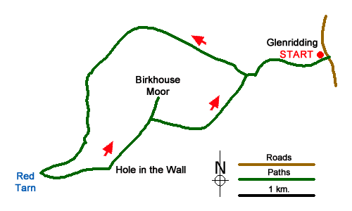
The start is Glenridding on the shores of Ullswater where a large pay and display car park is located on the west side of the A592 (grid ref. NY386169). After parking exit the car park and turn right over Glenridding Beck. Turn first right in front of the shop following the bridleway to Helvellyn. Continue along the bridleway bearing right at the first junction towards Gillside. The bridleway continues with the Beck on your right-hand past a campsite to reach a lane (grid ref. NY386169).
Turn left, walking uphill to Helvellyn via Miresbeck. Ignore the path on the right to Greenside and continue to a path junction (grid ref. NY377167). Turn right and continue climbing to a stile (grid ref. NY376166). Turn right and, with the intake wall on your right, continue up Glenridding. The path ahead is well trodden and, after a level section by the intake wall, turn southwest and climb steadily past a sheepfold (grid ref. NY357168) and up beside Red Tarn Beck to Red Tarn (grid ref. NY350154).
After enjoying the magnificent surroundings of Red Tarn which includes Catstye Cam, Helvellyn, Swirral Edge and Striding Edge take the path heading east from the Tarn out-flow to the Hole-in-the-Wall (grid ref. NY359155). Turn left along the wall (wall to your right) and continue straight ahead to reach the cairn on Birkhouse Moor (grid ref. NY365164) from where you can enjoy a wide panorama of the surrounding fells and much of the route you have just undertaken.
To continue, retrace your steps back to the main path and turn left, again keeping the wall on your right. After about 600 metres beside the wall turn left at a large cairn to descend quite steeply into Little Cove where you re-join the outward route at a stile (grid ref. NY376166). From here retrace your steps back to the start.
Messaging & Social Media
Message Walking Britain and follow the latest news.

Mountain Weather
Stay safe on the mountains with detailed weather forecasts - for iOS devices or for Android devices.