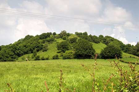
Duncryne from Gartocharn
Loch Lomond and Trossachs Walk
Nat Park - Loch Lomond and Trossachs
County/Area - West Dunbartonshire
Author - Lou Johnson
Length - 2.0 miles / 3.3 km Ascent - 280 feet / 85 metres
Time - 1 hours 20 minutes Grade - easy
Walk Route Description
Click image to see photo description.
This short but rewarding walk to the summit of Duncryne, nicknamed the Dumpling, offers a fine view along the length of Loch Lomond and to the Campsie Fells to the south. The route starts from the village of Gartocharn which straddles the A811 which follows the route of an old Military Road.
Limited on-street parking is available in Gartocharn on Church Road (grid ref. NS428862) on the north side of the A811. After parking walk back to the main road and turn left. Continue a short way and turn right into Duncryne Road just before the playground. Follow the road as it climbs gently out of the village. After 800 metres, just past the last house on the left, turn left through a gate into woodland. The well-maintained path follows the edge of the wood through a gate and into open countryside. The path runs between fences through another gate to reach the hilltop with a light covering of trees and gorse.
After a final, short climb you reach the summit of Duncryne which is marked with a concrete OS trig column (142 metres above sea level). The view north looks along the length of Loch Lomond with Ben Lomond rising on the right-hand side of the loch. Looking north the view is dominated by the Campsie Fells. After enjoying the view retrace your steps back to the start.
Maps 

| Ordnance Survey Explorer OL38 | Sheet Map | 1:25k | BUY |
| Anquet OS Explorer OL38 | Digital Map | 1:25k | BUY |
| Ordnance Survey Digital Map Subscription | |||
| Latest Ordnance Survey Discounts | |||
Other walks nearby
| Walk 2659 | Conic Hill | easy/mod | 4.0 miles |
| Walk 2765 | Conic Hill Circular | easy/mod | 7.0 miles |
| Walk 1492 | WHW - Day 2 - Dryden to Rowardennan | moderate | 15.0 miles |
| Walk 1296 | Beinn Eich & Doune Hill | mod/hard | 8.0 miles |
| Walk 3009 | Ben Lomond | mod/hard | 7.5 miles |
| Walk 1493 | WHW - Day 3 - Rowardennan to Inverarnan | moderate | 14.0 miles |
| Walk 2552 | West Highland Way Experience | moderate | 95.0 miles |
| Walk 1490 | West Highland Way - A personal experience | moderate | 96.0 miles |
| Walk 1491 | WHW - Day 1 - Milngavie to Drymen | moderate | 12.0 miles |
| Walk 2413 | Ben Venue from Loch Achray | moderate | 8.2 miles |
Recommended Books & eBooks
Walking Loch Lomond and the Trossachs
 A guide to walking and scrambling routes in the beautiful Loch Lomond and the Trossachs National Park. Over 70 graded low-level, mid-level and mountain walks taking in hills, glens and picturesque woodland, as well as all of the region's Munro summits. Highlights include Ben Lui, Ben Lomond, the Cobbler and the Arrochar Alps.
More information
