Walk 2356 - printer friendly version
The Cairnwell ridge from Glenshee Ski Centre Walk
Author - Lou Johnson
Length - 9.3 miles / 15.1 km
Ascent - 2000 feet / 606 metres
Grade - mod/hard
Start - OS grid reference NO140780
Lat 56.8853700 + Long -3.4129888
Postcode AB35 5XU (approx. location only)
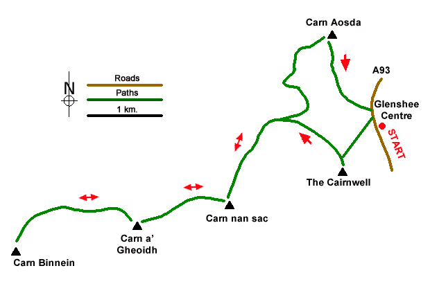
The Cairnwell rises above the Glenshee Ski Centre on the A92 between Spittal of Glenshee and Braemar. Rising to 935 metres, it is a Munro and connected by ridges to Carn nan Sac (920 m), Munro Carn a' Gheoidh (975 m), Carn Bhinnein (915 m) and Munro Carn Aosda (915 m). Together, the four summits make an excellent ridge walk and a not too demanding walk offering views across the southern part of the Cairngorm National Park. Note - this is an unrewarding walk in poor visibility so choose fine weather to complete the route.
The start is the large car park (grid ref. NO140780) on the east side of the A92 at the Glenshee Ski Centre. After parking cross the road and use the chairlift to the summit of the Cairnwell. Do check before that the ski lift is in operation at www.ski-glenshee.co.uk. Exit the ski lift and head left to the summit of the Cairnwell. The view is excellent and includes much of the walk. To continue return past the ski lift and initially follow the signs to Carn Aosda. Descend to a saddle, pass through a gap in the fence and start to climb. Just beyond a sign to Carn Aosda and Loch Vrotachan you reach a cairn where you fork left and descend to another cairn on the top of Creag a' Choire Dhirich (grid ref. NO127781) at spot height 808 m. Make a note of its position as you will return here later in the walk.
Fork left along a path along the edge of sheer cliffs on your left. Keep well away from the edge especially if there are strong winds. Continue past two lochans on your left and climb across a boulder field to the summit of Carn nan Sac (grid ref. NO119770). Descend to the west and across the Coolah. Another ascent leads to Carn a' Gheoidh with its small wind shelter. The next section of the route is mostly pathless with the walker choosing their own route. First descend west down the ridge and then veer half-left to pass to the left of a lochan. Continue up the well-defined ridge to the summit of Carn Bhinnein. Enjoy the excellent view down Glenshee and the surrounding mountains.
Retrace your steps to spot height 808 m. (grid ref. NO127781) mentioned in paragraph 2. Rather than return to the Cairnwell, fork left and follow the path past a hut to reach the summit of Carn Aosda with its boulders and rocks. To start the final descent, walk back about 100 metres and turn left to descend on a path between the ski tows back down to the start.
Messaging & Social Media
Message Walking Britain and follow the latest news.

Mountain Weather
Stay safe on the mountains with detailed weather forecasts - for iOS devices or for Android devices.