Parc le Breos near Parkmill Walk
Walk 2358 - Route Maps
Route Map
Digital Maps - Copyright © 2011-2024. All rights reserved.
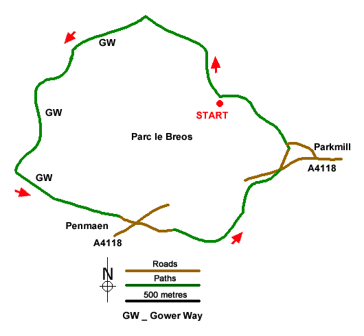
Sketch Map
Suggested Maps 

| Ordnance Survey Explorer 164 | Sheet Map | 1:25k | BUY |
| Anquet OS Explorer 164 | Digital Map | 1:25k | BUY |
It is recommended you take a map. The preferred scale is 1:25k.
Start Point Details
Ordnance Survey Grid Ref SS538896
Latitude 51.586236 Longitude -4.111668
Postcode SA3 2EH
what3words start type.cuff.marzipan
Walk description may contain detailed information on the start point for this walk.
Further Information
Gower Peninsula
The Gower or the Gower Peninsula is projects west into the Bristol Channel. Part of the City and County of Swansea, the Gower became the first area in the United Kingdom to be designated an Area of Outstanding Natural Beauty in 1956. Gower Peninsula Walking Guide
Walk grading - Learn how each walk is assessed and select a walk to suit your ability and experience by going to Walk Grading Details.
Messaging & Social Media
Message Walking Britain and follow the latest news.

Mountain Weather
Stay safe on the mountains with detailed weather forecasts - for iOS devices or for Android devices.