Clough Head via Great Dodd from near Dockray
Lake District Walk
Nat Park - Lake District - Lake District Eastern Fells
Wainwrights - Clough Head, Great Dodd
County/Area - Cumbria
Author - Lou Johnson
Length - 8.1 miles / 13.2 km Ascent - 2000 feet / 606 metres
Time - 6 hours 0 minutes Grade - moderate
Walk Route Description
Click image to see photo description.
Clough Head is the most northerly summit on a long ridge of hills stretching north from Ambleside and offers an excellent panorama across the Lake District Fells. The route starts from above Dockray and crosses Matterdale Common to Great Dodd. From here the walk continues over Calfhow Pike to Clough Head's summit. The descent route joins the Old Coach Road for an easy return to the start.
The start is the parking area at High Row (grid ref. NY380219) above Dockray. After parking, take the unsigned track (The Old Coach Road), pass through a gate, and continue with a plantation on your right to where the track bends sharp right. Cross Grove Beck and turn left onto a rising path with Grove Beck below on your left. The path steadily across open fell soon reaching Matterdale Common which is crossed in a south-westerly direction with the slopes of Great Dodd rising ahead. After passing the rocky knoll of Randerside, the gradient steepens to reach the summit of Great Dodd with its small cairn (grid ref. NY342206). Take time to enjoy the extensive view across Lakeland.
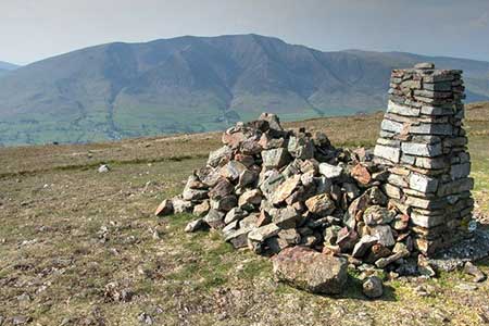
Initially descend to the west along a path which soon swings north-west and descends to the rocky outcrop of Calfhow Pike. After a short descent the path climbs easily to reach Clough Head with its OS trig column and a rudimentary stone windbreak. The view to Blencathra is particularly noteworthy. To start the descent, follow the clear path heading northeast. After 500 metres your reach the rocks of White Pike (grid ref. NY339229) which is worth a few minutes climb to enjoy the view. Just before reaching the rocks, you reach a cross path. To continue the descent, turn right and descend steeply at first on a mostly clear path heading east towards the Old Coach Road. Which is clearly visible ahead in fine weather.
Reaching the track (grid ref. NY348230), turn right and continue for about four kilometres of easy level walking back to the start.
Maps 

| Ordnance Survey Explorer OL5 | Sheet Map | 1:25k | BUY |
| Anquet OS Explorer OL5 | Digital Map | 1:25k | BUY |
| Ordnance Survey Digital Map Subscription | |||
| Latest Ordnance Survey Discounts | |||
Other walks nearby
| Walk 2039 | Gowbarrow Fell circular | moderate | 3.5 miles |
| Walk 1156 | Helvellyn via Striding Edge | hard | 9.5 miles |
| Walk 1235 | Red Tarn & Grisedale | moderate | 7.0 miles |
| Walk 1710 | Glenridding, St. Sunday Crag & Helvellyn | hard | 11.5 miles |
| Walk 3232 | Glenridding Dodd & Sheffield Pike | easy/mod | 4.5 miles |
| Walk 2327 | Red Tarn & Birkhouse Moor from Glenridding | moderate | 6.0 miles |
| Walk 3668 | Catstye Cam from Glenridding | mod/hard | 7.0 miles |
| Walk 1143 | Hallin Fell | easy | 2.0 miles |
| Walk 1241 | Arthur's Pike & Loadpot Hill | moderate | 9.0 miles |
| Walk 1242 | Bannerdale, Boredale & Beda Head | moderate | 9.0 miles |
Recommended Books & eBooks
Walking the Lake District Fells - Mardale and the Far East
 Part of the Walking the Lake District Fells series, this guidebook covers a wide range of routes to 36 Lakeland summits that can be climbed from the Ullswater, Haweswater, Troutbeck, Kentmere and Longsleddale valleys, with highlights including High Street, Place Fell and the Kentmere fells. Suggestions for longer ridge routes are also included.
More information
Lake District: Low Level and Lake Walks
 This guidebook describes 30 of the best low-level walks in the Lake District. From delightful wooded glades and sparkling tarns, to waterfalls and glacier-carved valleys towered over by craggy mountains. The walks described aim to seek out the best walking that the lower areas of the Lake District have to offer.
More information
