Walk 2380 - printer friendly version
The Malverns from the Gullet Walk
Author - Peter Lane
Length - 12.0 miles / 19.5 km
Ascent - 2700 feet / 818 metres
Grade - moderate
Start - OS grid reference SO766382
Lat 52.041019 + Long -2.342110
Postcode WR13 6BX (approx. location only)
Clearly visible for miles around and with all the main parking areas within five to ten minutes walk from the ridge itself the Malverns are perennially popular given their accessibility and unique status as the most prominent hills in the area. This walk starts at a little known parking area at the foot of the Gullet and visits the main peaks of Herefordshire and Worcestershire Beacons with an optional trip to the monument on the Eastnor Estate.
As a North - South ridge walk the Malverns make a circular trip a tricky prospect, but this walk goes a long way towards achieving this goal without losing too much height by flanking some peaks on the return leg. Of course, if you plan to do this walk as part of a training regime, feel free to summit all the peaks on the way out and the way back and upgrade difficulty to "Hard" if you do.
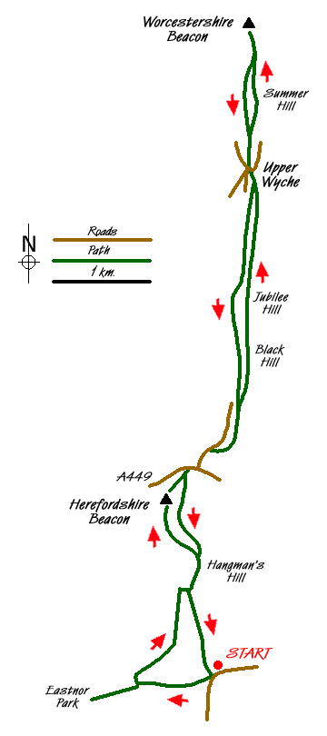
The starting point is Swinyard car park on Castlemorton Common, grid reference SO766382. Turn West out of the car park, off the main road up a metalled lane that turns into "The Gullet". Part way along is a pool, the result of quarrying, and an information board. The Gullet emerges onto the main North - South path at a cross-roads, with a kissing gate opposite leading onto the Eastnor Estate. It is worth the 10 - 15 minute diversion into the Estate to look at the monument (visible for many miles around, particularly from Herefordshire Beacon) and the view from its foot.
Returning to the kissing gate, turn North along a muddy section through woodland until reaching a cattle grid and gate. Here turn right and climb fairly steeply until the main ridge is gained. Continue North to Hangman Hill (follow the stone marker where the path turns sharply to the right from the woodland). After another short steep climb reach the low mounted circular orientation plaque. This forms the base for an ascent of Herefordshire Beacon (also known as British Camp). Our return route is to the right of the Beacon here, descending towards (but not visiting) a reservoir. Proceed up the clear path, flagged in places, to Herefordshire Beacon. The Beacon has been extensively terraced to form motte and bailey defences.
Leave the summit of the Beacon down the well paved route and emerge at the car park below on the county border with Worcestershire. Cross the busy A449, pausing if desired at the open air café or hotel opposite for refreshment. Continue North along the B4232 for a couple of hundred metres and at a car park on the right find your way swiftly back to the ridge. The onward route presents no navigational challenge whatsoever, summiting in turn: Black Hill, Jubilee Hill and Perseverance Hill. On the return route you may decide to flank some of these peaks - take careful note of the flanking routes which are all to the West (left on the outward trip) a short distance away from the main ridge.
The ridge drops down to the left to cross the road at Upper Wyche where there are toilets. Cross the road and take the upward climbing lane that leads to a pay and display car park. Regain the ridge on the right as soon as possible (before the main car park area) and continue bagging peaks for as far as you wish to go! Summer Hill (flanking route to the West again) is followed by the Worcestershire Beacon. After all the climbing, take a chance for a break! If feeling particularly energetic you can bag North Hill before returning, but this route is based on Worcestershire Beacon as being the most Northerly point.
Retrace to Upper Wyche, flanking Summer Hill if you wish, then retrace to the Hotel and café on the A449 again flanking as many hills as you wish. Now take the path from the car park and keep to the left of Herefordshire Beacon (unless you're a real sucker for punishment) following a gently rising path past the reservoir down below to the left. Reaching the orientation plaque at Hangman Hill retrace to the sharp descent on the right that returns to the woodland. The car park is visible in the distance from this point before turning right into the woodland. Bear left and coming shortly to a fork at the bottom of the slippery descent, take the wide left branch that descends gently down to the car park.
Messaging & Social Media
Message Walking Britain and follow the latest news.

Mountain Weather
Stay safe on the mountains with detailed weather forecasts - for iOS devices or for Android devices.