Walk 2408 - printer friendly version
Ebrington & Hidcote from Ilmington Walk
Author - Lou Johnson
Length - 8.0 miles / 13 km
Ascent - 1000 feet / 303 metres
Grade - easy/mod
Start - OS grid reference SP210433
Lat 52.087656 + Long -1.6949263
Postcode CV36 4LD (approx. location only)
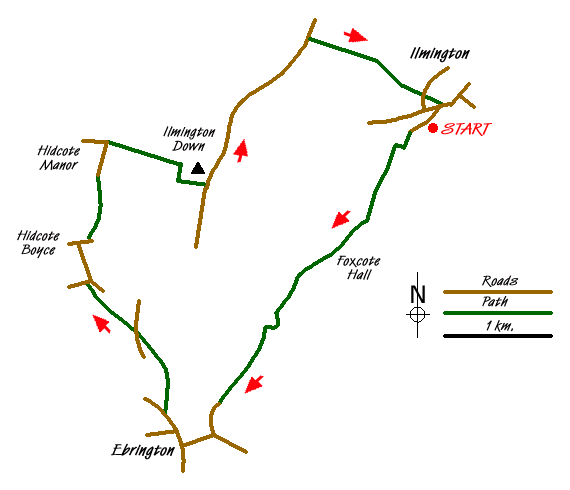
This walk explores the most northerly hills of The Cotswolds. Starting in the Warwickshire village of Ilmington, the route continues into Gloucestershire to visit one of the county's most picturesque villages. From here the walk continues through pleasant rolling countryside to reach Hidcote, where you may visit one of Britain's finest gardens, before climbing onto Ilmington Down to pass the highest point in Warwickshire.
The start is in the village of Ilmington where limited parking is available around the village green in front of the small Roman Catholic Church (Grid ref. SP210433). Take the lane immediately in front of this Church and follow it southwest between houses and cottages. Gaining height the lane reaches a large gate (Grid ref. Grid ref. SP206429). Do not go through this, instead turn right through a smaller metal gate and then almost immediately left through another gate onto a footpath. This path climbs through fields with a boundary fence on your left.
The climb is over when you reach Pig Lane (Grid ref. SP204425) where you go straight across and descend into the parkland surrounding Foxcote House. In a short way you reach a tarmac drive. Turn right and follow this past the entrance to Foxcote House and on to Foxcote Farm. Here you keep straight ahead on a track. The bridleway is shown as taking a short cut across a field (Grid ref. SP194413), however it is easier to follow the track as there is no evidence of a route across the field. The track takes you into Gloucestershire and becomes Nash's Lane leading you without problem into the picturesque village of Ebrington.
Turn right on reaching the road and walk through Ebrington to reach a road junction by the pub, which is on your left. Turn right here and continue past some very attractive thatched cottages in the direction of Mickleton. Continue past the school to reach a signed footpath on your right. There is also a sign to the 'Recreation Ground'. Take this track which soon becomes a path and walk through meadows following the clear waymarks to reach a lane (Grid ref. SP180411). Go straight across and follow the onward path across more meadows to reach a lane (Grid ref. SP175416) at a T-junction. Take the lane into the small hamlet of Hidcote Boyce. Turn right in the village. Just after the last building on your left take the signed path half left across fields towards Hidcote Bartrim.
Reaching a road, walk past the cottages to reach the entrance to Hidcote Manor on your left. Administered by the National Trust, this is the home of one of Britain's great gardens (admission fee payable). In addition there is a plant centre where a small café provides refreshments in season. Continue along the lane to reach a road junction (Grid ref. SP177430). Turn right here and follow the track uphill onto Ilmington Down. Reaching a junction in track, turn right and follow the track left to reach a radio station. You are now close to the highest point in Warwickshire.
Just past the radio station turn left down a narrow tarmac lane. Offering excellent views west and north you descend steadily. After just over a mile there is a driveway on your right (Grid ref. SP197440). Turn right into this for a short way and locate a signed footpath on your left just before the gates to the private drive. You are now on the Centenary Way. Follow this path around a field with the hedge on your immediate right to reach a gate. Continue along the path rising for a short way to reach a path junction marked on the map but with little evidence on the ground (Grid ref. SP204438). Take the right fork.
The path descends into a dell before climbing a short way and than crossing a field with a marker post to help navigation. At the top of this field ignore the path on your right but continue down a wide grassy path between hedges. This leads you down to gates marked as no right of way. Go left through a gate and then down a narrow enclosed path which you leads down to a road. Opposite is the Parish Church in Ilmington. Cross the road and take the path to the right of the churchyard. At the first path junction, bear right and this will lead you to a road. If you require refreshments then there is a pub in the village and this can be reached by turning left and walking a few hundred metres with pub on your left, otherwise your car will be parked somewhere opposite by the village green.

Mountain Weather
Stay safe on the mountains with detailed weather forecasts - for iOS devices or for Android devices.

