Walk 2412 - printer friendly version
Craiggowrie & Creagan Gorm from Loch Morlich Walk
Author - Andy Smith
Length - 7.3 miles / 11.9 km
Ascent - 1800 feet / 545 metres
Grade - mod/hard
Start - OS grid reference NH974098
Lat 57.167534 + Long -3.6982675
Postcode PH22 1QY (approx. location only)
There are many Corbetts or hills between 2500 and 3000 feet high in the Cairngorms. These are often overlooked in favour of the much higher Munros or hills over 3000 feet high. This route takes in the two named summits on the west ridge of Meall a'Bhuachaille which overlooks the north side of Loch Morlich to the east of Aviemore. For purists the actual Corbett top of Meall a' Bhuachaille can also be included quite easily by continuing east along the ridge before descending back to Loch Morlich. Despite the modest height of these hills, this can be quite a demanding walk as the ridge is very exposed and high wind very much an issue. This route has been completed in both directions and the one below is without doubt the best option for views.
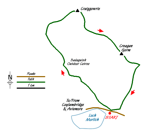
There is a large car park located on the banks of Loch Morlich (grid ref. NH974098). After parking for a small fee leave the car park and cross the road with care onto the parallel path heading east. Within minutes a large forest track appears on your left doubling back on itself, take this and start climbing into the forest. Ignore any junctions and continue on the main track until the Badaguish Outdoor Centre is reached. At the time of writing (April 2009) there has been intensive logging in this area so do not be surprised at differences between the map and reality.
Once the outdoor centre is reached follow the path keeping the centre to your left. You soon leave the centre and cross a burn at grid ref. NH956115 where you bear right uphill. Follow the track deep into the forest which seems to take quite a while. After half an hour the track turns right onto a long straight. Half way along there is a well defined path to the right (grid ref. NH953122) heading due north. Take this and start climbing steeply out the forest.
Once away from the trees the going ahead is clear as you move slowly towards the cairn which is now in sight. Once on the summit views can be seen over Aviemore and beyond, quite often with snow capped tops for eight months a year. After enjoying the view, leave the summit and head southeast on the clear ridge path. You cross an unnamed intermediate summit (grid ref. NH968127) before starting the ascent onto Creagan Gorm. The ascent is a tough one but worth the effort as you are soon rewarded with great views in every direction. Far below Loch Morlich can be seen along with the path you took through the forest.
Leave the summit and continue southeast until your descent path is met (grid ref. NH985116). Once on the descent you will get some relief from the wind. Follow this path down through into the forest. Once back in the trees the path soon splits. Bear right and pass the pumping station until Glenmore Visitor Centre is reached. Here pass through the car park and turn right alongside the road for 300m back to the car park.
Messaging & Social Media
Message Walking Britain and follow the latest news.

Mountain Weather
Stay safe on the mountains with detailed weather forecasts - for iOS devices or for Android devices.