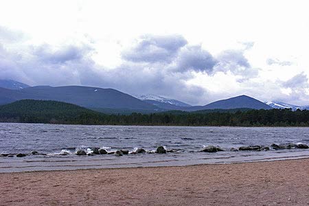
Craiggowrie & Creagan Gorm from Loch Morlich
Cairngorms Walk
Nat Park - Cairngorms - Cairngorm North
County/Area - Highland
Author - Andy Smith
Length - 7.3 miles / 11.9 km Ascent - 1800 feet / 545 metres
Time - 5 hours 30 minutes Grade - mod/hard
Maps 

| Ordnance Survey Explorer OL57 | Sheet Map | 1:25k | BUY |
| Anquet OS Explorer OL57 | Digital Map | 1:25k | BUY |
| Ordnance Survey Landranger 36 | Sheet Map | 1:50k | BUY |
| Anquet OS Landranger 36 | Digital Map | 1:50k | BUY |
Walk Route Description
Click image to visit gallery of 12 images.
There are many Corbetts or hills between 2500 and 3000 feet high in the Cairngorms. These are often overlooked in favour of the much higher Munros or hills over 3000 feet high. This route takes in the two named summits on the west ridge of Meall a'Bhuachaille which overlooks the north side of Loch Morlich to the east of Aviemore. For purists the actual Corbett top of Meall a' Bhuachaille can also be included quite easily by continuing east along the ridge before descending back to Loch Morlich. Despite the modest height of these hills, this can be quite a demanding walk as the ridge is very exposed and high wind very much an issue. This route has been completed in both directions and the one below is without doubt the best option for views.
There is a large car park located on the banks of Loch Morlich (grid ref. NH974098). After parking for a small fee leave the car park and cross the road with care onto the parallel path heading east. Within minutes a large forest track appears on your left doubling back on itself, take this and start climbing into the forest. Ignore any junctions and continue on the main track until the Badaguish Outdoor Centre is reached. At the time of writing (April 2009) there has been intensive logging in this area so do not be surprised at differences between the map and reality.
Once the outdoor centre is reached follow the path keeping the centre to your left. You soon leave the centre and cross a burn at grid ref. NH956115 where you bear right uphill. Follow the track deep into the forest which seems to take quite a while. After half an hour the track turns right onto a long straight. Half way along there is a well defined path to the right (grid ref. NH953122) heading due north. Take this and start climbing steeply out the forest.
Once away from the trees the going ahead is clear as you move slowly towards the cairn which is now in sight. Once on the summit views can be seen over Aviemore and beyond, quite often with snow capped tops for eight months a year. After enjoying the view, leave the summit and head southeast on the clear ridge path. You cross an unnamed intermediate summit (grid ref. NH968127) before starting the ascent onto Creagan Gorm. The ascent is a tough one but worth the effort as you are soon rewarded with great views in every direction. Far below Loch Morlich can be seen along with the path you took through the forest.
Leave the summit and continue southeast until your descent path is met (grid ref. NH985116). Once on the descent you will get some relief from the wind. Follow this path down through into the forest. Once back in the trees the path soon splits. Bear right and pass the pumping station until Glenmore Visitor Centre is reached. Here pass through the car park and turn right alongside the road for 300m back to the car park.
Other walks nearby
| Walk 1904 | Loch Morlich circular (near Aviemore) | easy | 4.0 miles |
| Walk 2607 | Lairig Ghru & Chalamain Gap from Glenmore | mod/hard | 11.0 miles |
| Walk 3579 | Meall a'Bhuachaille & Ryvoan Bothy from Glenmore | moderate | 5.5 miles |
| Walk 3218 | Eag a' Chait gap Via Rothiemurchus Lodge from Glenmore | moderate | 8.2 miles |
| Walk 1020 | Glenmore to Linn of Dee via Lairig Ghru & Corrour | hard | 21.0 miles |
| Walk 1605 | Loch an Eilein & Rothiemurchus Forest from Loch Morlich | easy/mod | 10.0 miles |
| Walk 2421 | Braeriach via the Chalamain Gap | hard | 15.0 miles |
| Walk 1881 | Ben Macdui & Cairn Lochan from the Ski Centre | hard | 10.4 miles |
| Walk 2672 | Cairngorm Mountain via Coire an t-Sneachda | mod/hard | 6.0 miles |
| Walk 1390 | Cairn Lochan via the Fiacaill Buttress from Ski Centre | very hard | 5.7 miles |
Recommended Books & eBooks
Walking the Munros Vol 2 - Northern Highlands and the Cairngorms
 Guidebook to walking the northern Munros, covering the northern Highlands, the Cairngorms and the Isle of Skye. 70 routes are described, including those up Ben Macdui, Braeriach and Cairn Gorm. Routes range from 7 to 46km, requiring a fair level of fitness. The second of two guidebooks to walking Scotland's Munros: peaks higher than 3000ft.
More information
Walking in Torridon
 This guidebook contains 52 day walks in Torridon, a remote and much-loved area of the Scottish Highlands. Based around Shieldaig and Slioch, the routes are split into 3 sections: easy walks, long and high level walks and mountain ascents over 2000ft including 9 Munros, and 5 outline suggestions for major ridge walks.
More information
Messaging & Social Media
Message Walking Britain and follow the latest news.

Mountain Weather
Stay safe on the mountains with detailed weather forecasts - for iOS devices or for Android devices.