Walk 2438 - printer friendly version
Cautley Spout & the Calf from Sedbergh Walk
Author - Lou Johnson
Length - 10.0 miles / 16.3 km
Ascent - 2300 feet / 697 metres
Grade - moderate
Start - OS grid reference SD659921
Lat 54.323323 + Long -2.5273159
Postcode LA10 5AD (approx. location only)
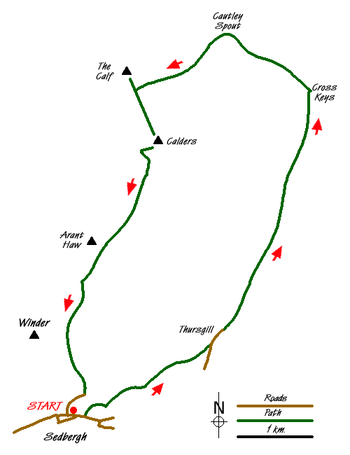
Starting from the small market town of Sedbergh, this walk in the Howgill Fells follows the River Rawthey upstream to Cautley. Turning northwest the walk passes Cautley Spout, one of the most dramatic waterfalls in the area, before climbing into the Howgill Fells. The route then visits the summit of the Calf, which at 676m, is the highest point in this range of hills, before returning to Sedbergh.
The start is the pay and display car park in Sedbergh (Grid ref SD659921) near the Tourist Information Centre. Leave the car park and walk east along Main Street to join Long Lane. Not far after the junction with Castlehaw Lane on your left take the signed footpath left (Grid ref. SD661921). This leads past a housing development on your right to join a lane - Thorns Lane. Continue ahead on this lane to Underbank (Grid ref. SD667925). Here take the footpath on your right that leads across fields passing below Stone Hall to bring you to Hollin Hill, which is passed on your left.
The onward path is generally easy to follow and you soon arrive at Ellerthwaite where you join a tarmac lane. Go left (east) along the lane which becomes a green lane after passing Thursgill. This is a beautiful section of the walk with the River Rawthey below on your right and pleasant views ahead. Hobdale Beck with its waterfalls adds interest as the green lane undulates towards Cautley.
There are few landmarks on this section and nearing Cautley you descend to cross a footbridge over Cautley Back. Just after, turn left (Grid ref. SD693967) and follow the clear road path northwest to reach the foot of Cautley Spout. After rain this waterfall is always an impressive sight and is one of the highlights of the Howgill Fells. The onward path takes you close to the falls and climbs steeply on a well made path on the right hand side of the waterfall. This path offers an intimate view of the falls and improving views down the valley.
Reaching the top follow the beck, taking the left hand stream, Red Gill Beck) at the first junction. A path follows this stream on the north side to reach a reconstructed sheepfold (Grid ref. SD676970). Andy Goldsworthy rebuilt this structure in his famous contemporary style and in many respects it is a pity that this work of art is hidden from view. Just past the sheepfold the stream splits again and this time take the right hand beck (Force Gill Beck) and follow this upstream to its source. Ahead of you is the col between Bram Rigg Top and the Calf with the main ridge path running between the two.
Turn right on this path and walk the short distance to the summit of the Calf from where there is an extensive panorama containing most of the Howgill Fells. After having enjoyed the view return down the path and continue over Bram Rigg Top to Calders. Shortly after this summit the path makes a broad zig-zag down the fellside to cross the narrow ridge of Rowantree Grains (Grid ref. SD669954).
Stay on the main path (ignoring the rising path forking right to the summit of Arant Haw). After just under a kilometre, look out for a distinct path junction (Grid ref. SD660940). Here the main path continues ahead towards Winder with a less obvious path dropping away to your left. Take the latter and descend steadily with a stream, Settlebeck Gill, joining you on your left.
Descend with this path to intake wall and continue down hill to reach a track. Follow this track as it continues to descend to join a residential street (Joss Lane). This is followed down hill to reach the car park at the start.
Messaging & Social Media
Message Walking Britain and follow the latest news.

Mountain Weather
Stay safe on the mountains with detailed weather forecasts - for iOS devices or for Android devices.