Walk 2439 - printer friendly version
Forth & Clyde Canal & Antonine Wall Walk
Author - Rob Kay
Length - 6.0 miles / 9.8 km
Ascent - 720 feet / 218 metres
Grade - easy
Start - OS grid reference NS719769
Lat 55.96796 + Long -4.0539271
Postcode G65 9SG (approx. location only)
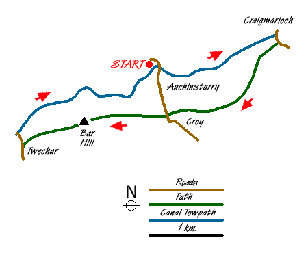
A circular, low-level route taking in some of the best sections of both the Forth & Clyde canal and the Roman Antonine Wall.
The walk starts at Auchinstarry Marina (grid ref. NS719769), a haven for many small craft, and proceeds along the canal towpath in an easterly direction for a mile and a half to Craigmarloch (Grid ref. NS737774). Turn right over the bridge and continue uphill towards Condorrat on the minor road for a couple of hundred yards then climbing steadily, follow the signs to the Antonine Wall and continue along the ridge to Croy for a couple of miles, with superb views over the Kilsyth Hills to the north. The Antonine Wall is clearly visible to your right as a deep ditch and embankment.
Past Croy, cross the main road and continue along the good path to Barr Hill for a mile, where you can view the excavated ruins of an excellent Roman fort with bath-house and underfloor heating. Continue downhill to Twechar - the excellent local pub offers liquid refreshment but no food. At Twechar turn right down to the canal swing bridge, turn right, and proceed along the canal for a mile or two back to Auchinstarry. A pub and hotel complex is being built and will offer food and accommodation from early 2007.
Messaging & Social Media
Message Walking Britain and follow the latest news.

Mountain Weather
Stay safe on the mountains with detailed weather forecasts - for iOS devices or for Android devices.