Walk 2455 - printer friendly version
Lum Edge & Revidge Moor Walk
Author - Lou Johnson
Length - 6.5 miles / 10.6 km
Ascent - 750 feet / 227 metres
Grade - easy/mod
Start - OS grid reference SK086587
Lat 53.1254010 + Long -1.8729378
Postcode SK17 0JG (approx. location only)
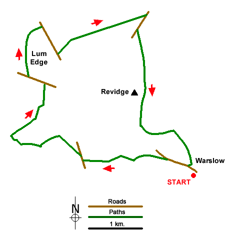
Starting from Warslow this Peak District walk includes Lum Edge and Revidge two of the higher areas of land in the vicinity. The route needs careful navigation and the use of the relevant OS 1:25k map will prove useful. The area covered by the walk has a complex network of paths with some seeing very little use.
The start is Leek Road somewhere near the Greyhound Inn in Warslow (grid ref. SK086587). After parking walk out of the village along Leek Road. Just past a wooden bench and lane on the left, fork left off the road along a walled track. The track arcs left and then bends left again. Turn right off the track here (grid ref. SK077589) to follow a path across two fields and into trees. Exiting the trees cross a footbridge and head half-left across a field. The onward path crosses a steam and then continues west with a wall on your right to reach Stoneyfold Lane.
Turn right and after 140 metres turn left over the wall by a fingerpost. The path initially follows a wall on your right but soon passes through a gap and continues with a wall on your left. When the wall ends maintain direction across the next field to a gate, pass through another gate and then head half-left over a larger field to join a track (grid ref. SK065 592). Turn left and pass through three gates. Immediately after the third gate turn right along a wall to briefly join a track. Just after a large tree on the right, leave the track and cross two fields to enter woodland.
Cross a footbridge and turn right. Cross the next footbridge and head steeply uphill heading northeast and keeping to the right of another stream. Pass a pond and continue to a stile. Bear left to Averhill Side Farm. Keep ahead through the farmyard to join a clear track heading north. Follow this to a road (grid ref. SK063601). Turn left and after 300 metres cross a stile over a fence on the right which provides access to Lum Edge. A feint path heads north along the edge. You cross several stiles as you head to the highest ground along the edge. The onwards path briefly runs beside a wall on your left, before maintaining direction across heather moorland. Reaching a series of outcrops, with a view into the Upper Dove Valley and Chrome Hill, the path veers half right and leads to a road (grid ref. SK0636099).
Turn right along the road and continue past a plantation on your left. Just beyond the plantation turn left along the access drive to Big Fernyford Farm. After 320 metres, turn right through a gate (signed to Reeps Moor). The path maintains direction across some wet ground, continues along the right-hand edge of a small plantation, to reach a better track that continues ahead to reach a road (grid ref. SK079611). Turn right and just past the entrance to Shawfields Farm on your right, fork left to Cuckoostones. After 400 metres fork right and just after passing a small wood on your right, turn right up some steps and continue to the summit of Revidge marked with an OS trig column. Enjoy the extensive view which extends to the Manifold Valley and Thor's Cave.
Return to the track using the path heading south. Continue through woodland. Exiting the trees turn left through a small gate ignoring the large one ahead. The path follows a wall on your left, passes an old barn and continues to reach a farm access drive (grid ref. SK081593). Where the drive bends right, go sharp left into a field. The path runs beside a wall to a stile. Turn right and continue southeast across two fields before turning south to Warslow at a waymark. Reaching the edge of the village, the path bears right and exits into a housing estate. Continue ahead to Leek Road and turn left back to the start.
Messaging & Social Media
Message Walking Britain and follow the latest news.

Mountain Weather
Stay safe on the mountains with detailed weather forecasts - for iOS devices or for Android devices.