Walk 2484 - printer friendly version
Icomb & Wyck Rissington Circular Walk
Author - Lou Johnson
Length - 5.2 miles / 8.5 km
Ascent - 650 feet / 197 metres
Grade - easy/mod
Start - OS grid reference SP188218
Lat 51.8944370 + Long -1.7282058
Postcode GL54 2PN (approx. location only)
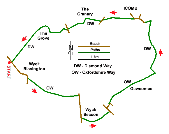
A classic Cotswolds walk visits two beautiful villages built from honey coloured stone, explores the rolling countryside, and offers views from the broad ridge of Wyck Beacon. The route uses sections of the Oxfordshire Way and Diamond Way which both have good waymarking. Do not be confused by the Oxfordshire Way as the walk remains in Gloucestershire throughout.
The walk starts from Wyck Rissington where a small grassy layby at the northern end of the village opposite a post box is a convenient place to park (grid ref. SP188218). After parking walk south through the village with its extensive green and village pond. Continue to St Laurence Church and enter the churchyard (signed Oxfordshire Way). Bear left to a fingerpost, pass through a kissing gate, cross a track, pass through another kissing gate, and cross a small field to footbridge in a hedge. Veer right and pass a barn to a gate in a hedge. The rising path leads to a gate and passes two ponds on your right. Veer right to cross a stream and then head left uphill to a kissing gate and a lane (grid ref. SP202212).
Turn right and continue past the entrance to Wyck Beacon Farm. Continue past a lane on the right and at the next fingerpost turn left (signed Oxfordshire Way). The path continues across the broad ridge of Wyck Beacon (trip column on your left). The path gently descends, passes through some trees, and exits onto the A424 (grid ref. SP207209). Turn left and then take the first lane on the right signed to Church Westcote. When the lane bends right, continue ahead on a waymarked track. Follow the track through trees and fork left to follow a clear track with farm buildings and cottages on the right. Reaching the last large barn on your right, turn right between barns and then left down a track fringed by trees.
After 200 metres turn left (grid ref. SP216216) onto a grassy path between trees. You are now following the Diamond Way which is used for the remaining walk back to Wyck Rissington. Pass through a gate and continue through woodland and through another gate into open countryside. Continue ahead over a footbridge to follow a path along the right-hand edge of a field. The path then passes a small reservoir on your right and joins a track. When the track bends right, continue ahead, and pass through a small gate on your right. Continue between hedges to the next small gate and head left along a good track into Icomb. Continue past the church to a memorial cross in the village centre (grid ref. SP213227).
Walk ahead towards the edge of the village. When the lane bears right cross the stile on the left with adjacent fingerpost. The rising path crosses fields, briefly passing through trees to reach a lane (grid ref. SP205226). Cross to the farm track opposite leading to The Granary. Walk past the house, pass between barns, and turn left on a path through woodland. Exit the trees and follow the path along the left-hand edge of a field to pass through a small wooden gate to the A424 (grid ref. SP199225). Cross thro rad with care to the signed bridleway opposite. Pass through woodland to a tarmac track. After 200 metres fork right Fork right again off the main track to join lesser track with woodland on your immediate right. The track soon bends right and then arcs left with woodland on your left. Continue ahead past the Lodge and the track soon leads to the road through Wyck Rissington. If you parked where suggested turn right back to the small layby.
Messaging & Social Media
Message Walking Britain and follow the latest news.

Mountain Weather
Stay safe on the mountains with detailed weather forecasts - for iOS devices or for Android devices.