Icomb & Wyck Rissington Circular
Pub Walk + Countryside + Villages
Region - Cotswolds
County/Area - Gloucestershire
Author - Lou Johnson
Length - 5.2 miles / 8.5 km Ascent - 650 feet / 197 metres
Time - 3 hours 20 minutes Grade - easy/mod
Maps 

| Ordnance Survey Explorer OL45 | Sheet Map | 1:25k | BUY |
| Anquet OS Explorer OL45 | Digital Map | 1:25k | BUY |
Walk Route Description
Click image to see photo description.
A classic Cotswolds walk visits two beautiful villages built from honey coloured stone, explores the rolling countryside, and offers views from the broad ridge of Wyck Beacon. The route uses sections of the Oxfordshire Way and Diamond Way which both have good waymarking. Do not be confused by the Oxfordshire Way as the walk remains in Gloucestershire throughout.
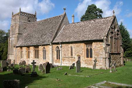
The walk starts from Wyck Rissington where a small grassy layby at the northern end of the village opposite a post box is a convenient place to park (grid ref. SP188218). After parking walk south through the village with its extensive green and village pond. Continue to St Laurence Church and enter the churchyard (signed Oxfordshire Way). Bear left to a fingerpost, pass through a kissing gate, cross a track, pass through another kissing gate, and cross a small field to footbridge in a hedge. Veer right and pass a barn to a gate in a hedge. The rising path leads to a gate and passes two ponds on your right. Veer right to cross a stream and then head left uphill to a kissing gate and a lane (grid ref. SP202212).
Turn right and continue past the entrance to Wyck Beacon Farm. Continue past a lane on the right and at the next fingerpost turn left (signed Oxfordshire Way). The path continues across the broad ridge of Wyck Beacon (trip column on your left). The path gently descends, passes through some trees, and exits onto the A424 (grid ref. SP207209). Turn left and then take the first lane on the right signed to Church Westcote. When the lane bends right, continue ahead on a waymarked track. Follow the track through trees and fork left to follow a clear track with farm buildings and cottages on the right. Reaching the last large barn on your right, turn right between barns and then left down a track fringed by trees.
After 200 metres turn left (grid ref. SP216216) onto a grassy path between trees. You are now following the Diamond Way which is used for the remaining walk back to Wyck Rissington. Pass through a gate and continue through woodland and through another gate into open countryside. Continue ahead over a footbridge to follow a path along the right-hand edge of a field. The path then passes a small reservoir on your right and joins a track. When the track bends right, continue ahead, and pass through a small gate on your right. Continue between hedges to the next small gate and head left along a good track into Icomb. Continue past the church to a memorial cross in the village centre (grid ref. SP213227).
Walk ahead towards the edge of the village. When the lane bears right cross the stile on the left with adjacent fingerpost. The rising path crosses fields, briefly passing through trees to reach a lane (grid ref. SP205226). Cross to the farm track opposite leading to The Granary. Walk past the house, pass between barns, and turn left on a path through woodland. Exit the trees and follow the path along the left-hand edge of a field to pass through a small wooden gate to the A424 (grid ref. SP199225). Cross thro rad with care to the signed bridleway opposite. Pass through woodland to a tarmac track. After 200 metres fork right Fork right again off the main track to join lesser track with woodland on your immediate right. The track soon bends right and then arcs left with woodland on your left. Continue ahead past the Lodge and the track soon leads to the road through Wyck Rissington. If you parked where suggested turn right back to the small layby.
Other walks nearby
| Walk 1360 | Naunton & the Slaughters | moderate | 11.0 miles |
| Walk 2283 | Church Westcote & Icomb Circular | easy/mod | 5.1 miles |
| Walk 1848 | Turkdean & Notgrove from Cold Aston | easy/mod | 6.5 miles |
| Walk 2076 | Kingham to Charlbury | easy/mod | 10.5 miles |
| Walk 2168 | The Slaughters | easy/mod | 8.6 miles |
| Walk 2454 | Farmington & Clapton-on-the-Hill | easy/mod | 6.4 miles |
| Walk 2186 | Adlestrop & Chastleton | easy | 3.8 miles |
| Walk 1439 | Fulbrook & Widford | easy | 6.0 miles |
| Walk 2094 | Snowshill Circular | easy | 4.4 miles |
| Walk 3327 | Temple Guiting & Cutsdean from Stanway | moderate | 10.0 miles |
Recommended Books & eBooks
The Cotswold Way Map Booklet
 Map of the 102 mile (163km) Cotswold Way National Trail, between Chipping Camden and Bath. This booklet is included with the Cicerone guidebook to the trail, and shows the full route on OS 1:25,000 maps. The trail typically takes two weeks to walk, and is suitable for walkers at all levels of experience.
More information
The Cotswold Way
 Guidebook to walking the Cotswold Way National Trail. Between Chipping Campden and Bath, the 102 mile route explores the Cotswolds AONB. Described in both directions over 13 stages, the Cotswold Way can be walked year round and is suitable for beginner trekkers. Includes separate OS 1:25,000 map booklet of the route.
More information
Messaging & Social Media
Message Walking Britain and follow the latest news.

Mountain Weather
Stay safe on the mountains with detailed weather forecasts - for iOS devices or for Android devices.