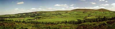
Fair Snape Fell from Fell Foot, Forest of Bowland
Forest of Bowland Walk
Region - Forest of Bowland
County/Area - Lancashire
Author - Paul Heap
Length - 6.0 miles / 9.8 km Ascent - 1680 feet / 509 metres
Time - 4 hours 40 minutes Grade - moderate
Walk Route Description
Click image to see photo description.
This excursion explores the Bleasdale Fells that occupy the south-western corner of the Forest of Bowland in Lancashire. Visible from the M6 motorway this range of hills is often neglected by many walkers but the area as a whole offers rich rewards for those willing to explore.
The start of the walk is Fell Foot (Grid ref. SD601442) a few miles to the north of the village of Chipping. Limited parking can be had on the road leading to Fell Foot (GR 602442) but can be limited during the summer months, so its recommended to get there early. From Fell Foot the path heads steeply up towards the summit of Parlick (432 metres). From here follow the fence line north dropping down to a col before climbing once again onto Blinhurst Fell. The path leaves the fence line (near a wind shelter) and heads north west to Fairsnape Summit (510 metres).
From Fairsnape summit follow a path north east to the junction of three fences which coincides with a spot height of 520 metres on the map. From this fence junction you have the options of either following the fence line east or picking up the path which heads south east (GR 598472) across Wolf fell (the later being the better path to follow) This path will eventually take you past the shooting butts leading to the stile to cross onto Saddle Fell.
From this stile the path starts descending to Saddle End farm. After passing through the farm turn sharp right to pick up the path (sign posted) to Wolfden Hall. This path takes you down to Chipping Brook which can be crossed via the footbridge. The path continues past Wolfden Hall. From here the path is onward route is signposted across the field to Wildcock House (ruin). Cross the stile and follow the fence line back to Fell Foot.
Maps 

| Ordnance Survey Explorer OL41 | Sheet Map | 1:25k | BUY |
| Anquet OS Explorer OL41 | Digital Map | 1:25k | BUY |
| Ordnance Survey Digital Map Subscription | |||
| Latest Ordnance Survey Discounts | |||
Other walks nearby
| Walk 1902 | Saddle Fell, Fair Snape Fell & Parlick from Chipping | moderate | 8.0 miles |
| Walk 2596 | The River Brock & Beacon Fell | easy/mod | 9.0 miles |
| Walk 1670 | Hazelhurst Fell, Fair Snape Fell and Parlick | moderate | 11.0 miles |
| Walk 2384 | Hodder Valley from Whitewell | easy/mod | 6.8 miles |
| Walk 1218 | Fiensdale Head & Bleasdale Water | moderate | 10.0 miles |
| Walk 2594 | Totridge Fell & Fiendsdale Head, Forest of Bowland | moderate | 11.0 miles |
| Walk 2508 | Dunsop Fell & the Forest of Bowland | moderate | 10.0 miles |
| Walk 2510 | Totridge Fell via Langden & Bleadale Water | mod/hard | 10.0 miles |
| Walk 2555 | Whitendale from Dunsop Bridge | moderate | 8.0 miles |
| Walk 2556 | Whitendale & Dunsop Fell from Dunsop Bridge | mod/hard | 15.0 miles |
Recommended Books & eBooks
Walking in the Forest of Bowland and Pendle
 A guidebook to 40 diverse circular day walks suitable for walkers with navigational skills. The Forest of Bowland and Pendle are two of north west England's upland AONBs, perfect for walkers who enjoy exploring rough hilly, sometimes pathless terrain. The routes include Ward's Stone, Pendle Hill, Longridge Fell and Fair Snape Fell.
More information
Walking on the West Pennine Moors
 This guidebook describes 30 walks on the West Pennine Moors, around Blackburn, Darwen, Chorley and Bolton, home to some of the most inspiring and exhilarating walking country. The walks range from short, easy rambles to more challenging hikes covering a variety of terrain, all of it easily accessible for day walking.
More information
