Walk 2508 - printer friendly version
Dunsop Fell & the Forest of Bowland Walk
Author - Mike Bexley
Length - 10.0 miles / 16.3 km
Ascent - 1420 feet / 430 metres
Grade - moderate
Start - OS grid reference SD661501
Lat 53.945886 + Long -2.5179707
Postcode BB7 3BB (approx. location only)
This is a beautiful walk so do not let the distance put you off as the walk back from the furthest point is easy. One word of warning - do not attempt this walk if the hills are in cloud unless you are confident at map reading and compass work. Like all moorland it is easy to get lost if you lack these skills.
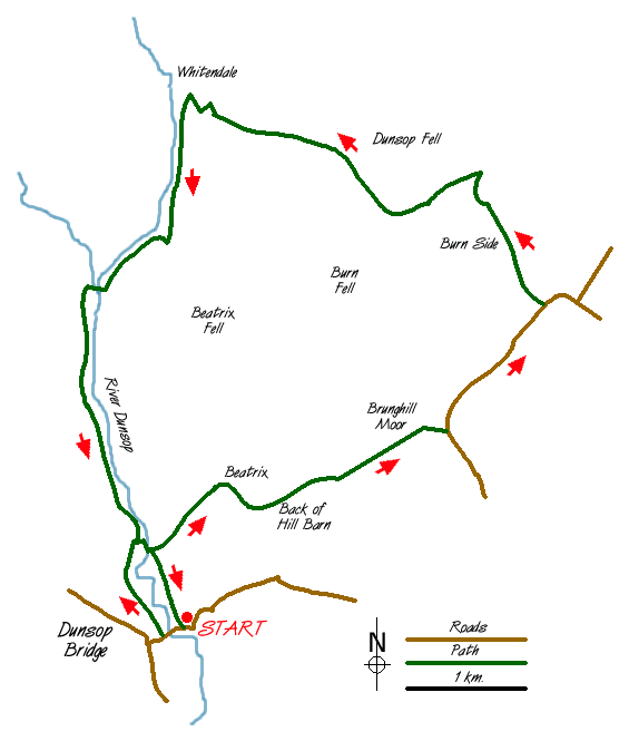
The walk starts at Dunsop Bridge (Grid ref SD661501) where there are toilets. Exit the car park (passing the toilet block) and cross over the road to the Telephone Box. Here you will discover Dunsop Bridge is the centre of The British Isles and that this phone box has a special number. Walk up the road over the river bridge and take the second road on the right past some Forestry Commission cottages on the left. This private road wanders down to the river.
Cross over the bridge and look for some steps up the steep bank on the left. Climb these and then continue straight on over the fields to Beatrix. Here you will join a narrow road. Turn left and follow the road to its end at 'Back of Hill Barn' where you need to locate the foot path going northeast. Follow this path over the stream until you reach a roofless barn on the right. Take the feint path to the left and go straight ahead keeping to the right of the ruins. At a wall you will find stone steps built in - they are there! Go over the wall and continue Northeast to reach Brunghill Moor farm (Grid ref. 682520). The path goes to the right of the farm to meet the farm drive. Turn right along this to the road.
Reaching the road turn left. Continue past New Biggin House and other cottages on right. Take the left drive to Burn Side (not Burn House). Follow this private road to the house where the path is clearly marked to pass to the right of the buildings. Now follow the path to the corner of the field and onto part of a Roman Road. Climb up this path with views on the right over towards Stocks Reservoir. This well defined path continues climbing on to Burn and Dunsop Fell.
The path becomes narrow and not so clear so look out for a wall ahead and a small gate. Go through this gate and you are now on Water Board property. The path ahead trends across the fells in a north-westerly direction and is very well marked with posts bringing you down to Whitendale (Grid ref. 661550).
Do not go down to the farm but take the path left on the eastern side of the river. This path, built by the Water Board, follows the river south. Look out for the large water pipes, which are from Thirlmere in the Lake District to Manchester. Also note the large flood barriers on the corners of this small stream which is subject to flash flooding. Oyster Catchers can also been seen in this valley.
Keep on this path over the wooden bridge and down to the service road on the western bank of the River Dunsop. Follow this service road south, passing the new salmon ladders and flood meadows until you reach the wooden bridge crossed at the start of the walk. Go over the bridge (don't go up the steps on the left unless you want to go around again), past the house and keep straight on across the meadows back to the start.
Messaging & Social Media
Message Walking Britain and follow the latest news.

Mountain Weather
Stay safe on the mountains with detailed weather forecasts - for iOS devices or for Android devices.