Walk 2516 - printer friendly version
Moscar, Dale Dike & Shrines Reservoirs Walk
Author - Mike Bexley
Length - 7.0 miles / 11.4 km
Ascent - 850 feet / 258 metres
Grade - easy/mod
Start - OS grid reference SK242884
Lat 53.391886 + Long -1.6375711
Postcode S6 6GL (approx. location only)
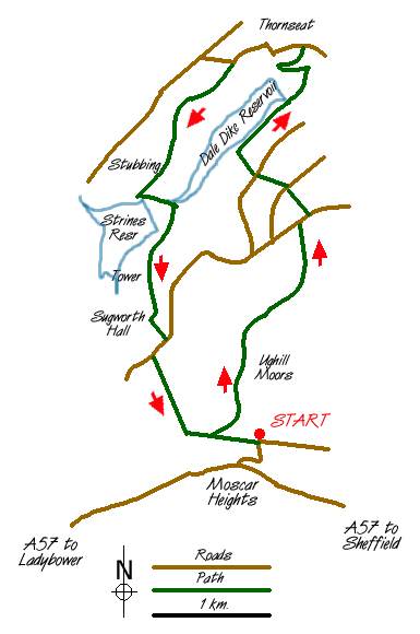
This fairly easy Peak District walk lacks high hills and very steep long climbs. However it is full of interest and beauty and is particularly pleasant in the autumn when the trees are changing colour. The start is a small lay-by (grid ref. SK242884) offering limited parking opportunities. This can be approached from the main A57 Sheffield to Snake Pass road by turning off to the north at Moscar Heights.
From the lay-by head west along a bridleway. After a short way (grid ref. 237885) head north along 'Stake Hill Road' another bridleway. Over to your left is a stone-built tower in the distance, more of that later. Keep north on the bridleway to reach a road. Turn right along the road turning left at the woods (grid ref. 246905). The path keeps to the western edge of the woods to reach another road.
At the road turn right then over the stile on the left. This path descends to a further minor road. Cross over and follow the steep path down with the woods on your right. Turn right into the woods at the stile (grid ref 240910) continuing on this woodland path. Take the first left through a very wet area down to Dale Dike Reservoir.
Follow the path keeping the reservoir on your left to reach the dam wall passing a small Water Board building that blends into the woodlands. The dressed stone dam with its iron railings replaced the original earth dam that collapsed in 1864 killing 240 people downstream. Despite this disaster this is a good place to stop for a sandwich and refreshment.
The path descends to the right of the outflow, down to the river, over the bridge then up through the woods bearing sharp right at the service road to pass a memorial to the people who were killed in the disaster. On reaching the road (grid ref. 245920) turn left. Stay on the road as it swings right at the farm drive with its 'no right of way notice to walkers'.
Take the path (grid ref. 239919) straight ahead to leave the road that turns and climbs right. This path leads you along Hall Lane then passes Hallfield House and Stubbing to reach Strines Reservoir at Brogging. Go down to the base of the dam, cross the river and wall and follow the path left to a stile. Do not go over the stile but take the higher path back southwest. This looks down to the right on Strines Reservoir.
The path climbs steeply past Sugworth Delf Quarry (Grid ref. 232901). The Tower that has always been in view during your walk is now on your right. It's worth crossing the field to take a closer look. It is called Boot's Folly and was built in 1927 to provide skilled work for the unemployed.
The footpath drops down to the rear of Sugworth Hall. Take the overgrown path through the little metal swing-gate, which leads you out onto the drive to the hall. Continue up the drive to the main gates where you will find facilities for walkers to exit the grounds. Turn right along Sugworth Road and over the first stile on your left. This straight path gradually climbs up Lodge Moor until you reach a bridleway. Turn left and keep straight on to where you started.
Messaging & Social Media
Message Walking Britain and follow the latest news.

Mountain Weather
Stay safe on the mountains with detailed weather forecasts - for iOS devices or for Android devices.