Walk 2524 - printer friendly version
Thirlmere Circular Walk
Author - Mike Bexley
Length - 5.0 miles / 8.1 km
Ascent - 350 feet / 106 metres
Grade - easy
Start - OS grid reference NY318196
Lat 54.567006 + Long -3.0563227
Postcode CA12 4TQ (approx. location only)
So you have half a day to spare! You have done the tops and you want a nice easy walk before you go shopping on the way home? Then this is the walk for you, offering wonderful views complemented with easy map reading and walking.
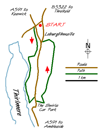
The walk starts at Legburthwaite car park (grid ref NY318196) just off the A591 Keswick to Ambleside main road. Under normal circumstances parking is usually easy and the car park has the benefit of toilets. After parking go through the northern gate and turn left along the lane to the main road. Cross the busy road to walk a short distance down the lane before going left then through the gate on the right.
Follow the wide path through the woods. At the farm gate (grid ref 315185) turn right up the hill to a path junction where you turn left. This lovely path follows Thirlmere's shore line with many places to walk down to the waters edge and admire the views across to the other side with Raven Crag to the right, High Seat ahead and the Watendlath Fells to your left.
Continue to follow this path. Eventually it climbs alongside one of the feeder streams back to the main road and a lay-by. Cross over the road and take the footpath opposite that descends to a further car park with toilets. This is an alternative starting point (grid ref 317168). Go to the far left hand corner of the car park then over the footbridge. This is camera time! The view north up 'St Johns in the Vale' with Blencathra in the background is a superb Lakeland landscape and must for inclusion in any photo album.
The footpath climbs up from the bridge for a short distance. Turn left at the path junction and follow the path that proceeds north with the wall on your left. Keep on this path passing waterfalls, over a footbridge spanning a gill until the end (grid ref 322189). Here you reach the path climbing up from Stybeck Farm (on the left) to Sticks Pass high in the hills on your right. Proceed down this footpath over the wall passing the farm and on reaching the lane turn right past the YHA building back to the start.
Messaging & Social Media
Message Walking Britain and follow the latest news.

Mountain Weather
Stay safe on the mountains with detailed weather forecasts - for iOS devices or for Android devices.