Walk 2535 - printer friendly version
Wildboarclough & Shutlingsloe from Trentabank Walk
Author - Mike Bexley
Length - 7.0 miles / 11.4 km
Ascent - 1700 feet / 515 metres
Grade - moderate
Start - OS grid reference SJ961711
Lat 53.236916 + Long -2.0598902
Postcode SK11 0NS (approx. location only)
The unique shaped Shutlingsloe (the local Matterhorn) is visible for most of the walk but its not until near the end that you can stand on its top and trace your route. From this low hill you have unrestricted views of Shining Tor, Kinder, The Cloud and the Mountains of Wales. The navigation looks more difficult than it really is but bear in mind the greatest challenges are some of the many stiles!
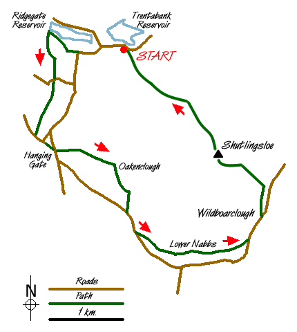
This Peak District walk starts from the Visitors Centre, in Macclesfield Forest (Grid ref. 961711) near Trentabank Reservoir. Proceed out of the car park and turn left down the road. Go left again up the minor road. At the corner take the wide path ahead continuing onto a forest path on your right that drops down to Ridgegate Reservoir. Follow the path to the left of the dam then over the stile on your left, walking down to the brook. Continue up through a broken wall to turn left on to the well-marked "Gritstone Trail".
This Trail takes you over fields passing farms en route. On reaching the second road (Grid ref. 950698) turn left. Walk up the road for a short way and then take the old footpath to the left of the cottage. This leads up to the back of the "Hanging Gate" pub. Cross over the road and follow the often wet bridleway opposite. On reaching the top, bear right following the path on High Moor to the large buildings at Oakenclough. Ahead of you across the moor is your first good view of Shutlingsloe. Turn right at the pond in front of the hall and follow a feint path leading you through the pretty Oaken Clough and its Highmoor Brook. The path ends at a road (Grid ref. 963687).
Head south along the road and take the farm track that climbs on the left. Leave this track at Lower Nabbs Farm and drop down to the fields on your right. Then continue straight across many fields and walls to reach the road (Grid ref. 981685).
Walk through Wildboarclough and take the steep lane on the left leading to Banktop (Grid ref. 982692). From here you take the path to Shutlingsloe, the summit of which is reached by an easy scramble. The hill can be avoided by taking the right fork roughly half way up. From the top descend via the path heading north. This is soon joined by the alternative path mentioned above. Follow the well worn path descending to Macclesfield Forest. Cross over the stile and then go left to reach the wide forest path descending through the forest to the visitors centre and your start.
Messaging & Social Media
Message Walking Britain and follow the latest news.

Mountain Weather
Stay safe on the mountains with detailed weather forecasts - for iOS devices or for Android devices.