Walk 2561 - printer friendly version
Digley & Ramsden Reservoirs from Wessenden Head Walk
Author - Mike Bexley
Length - 9.5 miles / 15.4 km
Ascent - 2290 feet / 694 metres
Grade - moderate
Start - OS grid reference SE077075
Lat 53.56406 + Long -1.8852178
Postcode HD9 4HP (approx. location only)
If it's variety you seek, then this is the Peak District walk for you. The route includes visits to the villages of Holmbridge and Holme, woodlands, secluded streams and the wide expanse of the moors. The footpaths are all well defined making very easy walking and map reading.
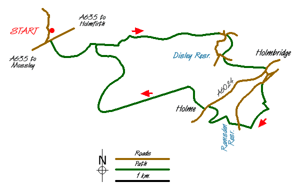
Starting from a small car park just off the A635 Mossley to Holmfirth Road (Grid ref. SE077075), walk south along the road to the main road. Cross over the stile opposite. Do not take the path signed Pennine Way. The path drops down the field and then bears left to follow the wall and edge of the woods. This path is often wet and stepping-stones have been taken from the wall. After the woods and a stile you join a green lane leading to Nether Lane. Keep to lower bridleway heading east passing Goodbent Lodge and ignoring the many paths to the left and right. There are some excellent views of the moors on you right and Digley Reservoir in the valley below.
Nether Lane ends at a tarmac road (Grid ref. 111075). Turn right and take the footpath on the left. This path crosses the field to another stile. Do not proceed to the farm ahead but turn right keeping the wall and hedge on your right. At the second stile diagonally cross the field dropping down to farm on your right. Direction arrows will indicate you to keep the farm and fence on your right, continuing down to a gate and steps to the road beneath the dam (Grid ref. 112070).
Cross over the road and go through the gate opposite. Then turn left to drop down through the woods to a tarmac lane. Turn left again along the lane with the river on your right terminating at the main road in Holmbridge and its cricket ground. Turn right over the river then first left up Bank Lane. Follow this lane round to the right and continue up to where another road comes in from the left. Just past this point you will see a footpath fingerpost pointing left.
Proceed up to the corner and go through the small gate along the drive in front of the house to the five-bar gate ahead. The path now climbs steeply through the woods at times zigzagging to reach a gated stile on to a bridleway, which is part of the Holme Valley Circular Walk (Grid ref. 120059). The high mast ahead of you is Holme Moss. Turn right, keeping the wall on your right and follow the wide path down to a stile. Turn right again down hill, passing the picnic chairs and tables to Ramsden Dam. Cross over the dam. Then turn right to follow the path around the edge of Brownhill Reservoir before dropping down to a footbridge deep in a glen. The onward path now climbs up to Holme village.
On reaching the main road turn left. Take the second road right. It is shown as a cul-de-sac but the road climbs passing the village school to become a bridleway. Ignoring the right turnings, the way leads to the very straight Issues Road. Ahead of you is Black Hill. At the end of Issues Road there is a footpath sign pointing right (Grid ref. 089058). This leads you to a beautiful wide path across the moors to a footbridge at Marsden Clough, which is known locally as Blackpool Bridge due to the very deep pool nearby. Climb up the steep path ahead, bearing left then up the field to a stile. Turn left on the green lane and over the steppingstones back to the start.
Messaging & Social Media
Message Walking Britain and follow the latest news.

Mountain Weather
Stay safe on the mountains with detailed weather forecasts - for iOS devices or for Android devices.