Lyme Park & Dissop Head Walk
Walk 2567 - Route Maps
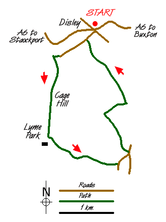
Route Map
Digital Maps - Copyright © 2011-2024. All rights reserved.
Sketch Map
Suggested Maps 

| Ordnance Survey Explorer OL1 | Sheet Map | 1:25k | BUY |
| Anquet OS Explorer OL1 | Digital Map | 1:25k | BUY |
| Ordnance Survey Landranger 109 | Sheet Map | 1:50k | BUY |
| Anquet OS Landranger 109 | Digital Map | 1:50k | BUY |
It is recommended you take a map. The preferred scale is 1:25k.
Start Point Details
Ordnance Survey Grid Ref SJ974846
Latitude 53.358272 Longitude -2.040528
Postcode SK12 2JB
what3words start sidelined.starts.hiring
Walk description may contain detailed information on the start point for this walk.
Further Information
Peak District
Walking in the Peak District is some of finest in the UK. The National Park suffers from a split personality with its contrasting White and Dark Peaks. Within easy distance from Manchester, Sheffield and the Midlands there is much for the visitor to see. The contrast between quiet limestone dales and wild upland moors provides the basis for a diverse range of Peak District walks with scenic variety the keynote. Peak District Walking Guide
Cheshire
The County of Cheshire offers a range of walks to suit all abilities. The Sandstone hills between Frodsham and Helsby offer fine walks with some excellent views across the Mersey Estuary. The flat land of the Cheshire Gap is dominated by pleasant rural farmland and easy walking. To the east of the county the land rises to the western moors of the Peak District National Park including the highest point at Shining Tor (559 metres) on the boundary with Derbyshire. It is in this area that most of the more challenging walks can be found with wild country and superb panoramas from the high ground.
Walk grading - Learn how each walk is assessed and select a walk to suit your ability and experience by going to Walk Grading Details.
Messaging & Social Media
Message Walking Britain and follow the latest news.

Mountain Weather
Stay safe on the mountains with detailed weather forecasts - for iOS devices or for Android devices.