Lyme Park & Dissop Head from Disley
Peak District Walk
Nat Park - Peak District - Goyt Valley Lyme Park
County/Area - Cheshire
Author - Mike Bexley
Length - 6.0 miles / 9.8 km Ascent - 900 feet / 273 metres
Time - 3 hours 50 minutes Grade - easy
Walk Route Description
Click image to see photo description.
This Peak District walk in Cheshire complements Walk 2523, again starting from Disley but avoids the climb up to Black Rocks. Ideal if the cloud is low or the weather uncertain, the start is from Disley on the A6, south of Manchester, convenient for anyone travelling by bus, rail or car.
Proceed up the minor road to the left of the Ram's Head (grid ref 975846) turning right at the first road behind the Rams Head. Then go right again at the road junction. Continue along this road passing large houses and boarding kennels to a large gate into Lyme Park (grid ref 967841).
Enter the park (no charge) then at the main entrance road, with its small hut, turn left then left again to follow a vehicle track that gently climbs at first in a south-east direction passing the Water Treatment Works on your left. Keep following the track bearing right at the wall and towards the top joining a wide path to the tower called The Cage (grid ref 966831), thought to be a vantage point in the past to watch stag hunting. It is certainly a vantage point to see Greater Manchester, parts of Cheshire and beyond.
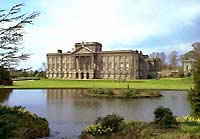
Continue in the same direction on the wide grassy path with the ridge on your right dropping down to a road. Turn right towards the great house then left through the metal gates, signed 'No Cycles'. Proceed along this short lane with the house and its gardens on your right. Go through another metal gate. Following the fence and Hampers Wood on your right continue to a high stile (grid ref 970822). You can go straight up here or alternatively follow the quarry road. Both routes lead to an old quarry. Still climbing, follow the wall to Lyme Park's boundary and go over the wall stile ahead.
In front of you in the valley lies Dissop Head, then The Moorside Hotel and behind it Black Hill (not to be confused with Black Hill near The Woodhead Pass) and in the far distance the hills of the Peak District. Follow the path down the fields to Dissop Head. On reaching the lane, turn left and walk to the road junction and entrance to the Hotel (grid ref 982822).
Turn left up the farm road - note the footpath finger post has not been replaced since the Foot & Mouth restrictions. At the farm house turn right through the footpath gate following the direction arrow to a stile in the bottom left corner. Go over the stile and the small stream to follow the path through the trees to a swing gate. Continue straight on following the indicator posts to a stile that leads onto a bridleway (grid ref 976830).
Turn right along this bridleway. Continue over a stream and then clamber over the first stile on your left which is located opposite a bridleway going right. After crossing the stile, keeping to the right-hand path that leads you to a further bridleway and Green Lane. Follow this lane to the end. At the road junction turn right to retrace you steps back to Disley. If you started from the railway station there is a footpath at the corner on your left leading down the station.
Maps 

| Ordnance Survey Explorer OL1 | Sheet Map | 1:25k | BUY |
| Anquet OS Explorer OL1 | Digital Map | 1:25k | BUY |
| Ordnance Survey Digital Map Subscription | |||
| Latest Ordnance Survey Discounts | |||
Other walks nearby
| Walk 2622 | Sett Valley & Kinder from New Mills | moderate | 10.0 miles |
| Walk 2329 | The Disley Lanes from Lyme Park | easy | 4.0 miles |
| Walk 1474 | Park Moor and Birchencliff from Lyme Park | easy/mod | 7.3 miles |
| Walk 1481 | Dale Top (Park Moor) from Lyme Park | easy | 6.3 miles |
| Walk 2557 | Lyme Park from Poynton | moderate | 10.0 miles |
| Walk 2528 | Kettleshulme & Sponds Hill | moderate | 8.0 miles |
| Walk 2546 | Lantern Pike & Cown Edge from Rowarth | easy/mod | 8.0 miles |
| Walk 2507 | South Head & Edale Cross from Hayfield | moderate | 8.0 miles |
| Walk 3407 | Chinley to Edale without a car | moderate | 9.3 miles |
| Walk 2534 | Chinley Churn & South Head | easy/mod | 7.5 miles |
Recommended Books & eBooks
Great Mountain Days in the Pennines
 An inspirational guidebook to 50 classic walks on the rolling Pennine landscape. The graded routes, between 6 and 13 miles in length, cover classic Pennine fells and moorland such as Whernside, Ilkley Moor and Pendle Hill; exploring the North and South Pennines, Yorkshire Dales, Howgills and Dark Peak. Many routes are also suited to fell running.
More information
Dark Peak Walks
 Guidebook to 40 walks in the Dark Peak area of the Peak District National Park. 35 circular routes for most abilities, from 8km to 19km, around Edale, Marsden, Fairholmes, Baslow and Castleton, including Kinder Scout and Mam Tor, and 5 longer (25km to 45km) routes highlighting the best of the Gritstone Edges, High Moorland and Deep Valleys.
More information
