Walk 2573 - printer friendly version
Tideswell, Miller's & Cressbrook Dales from Litton Walk
Author - Mike Bexley
Length - 7.0 miles / 11.4 km
Ascent - 1200 feet / 364 metres
Grade - easy
Start - OS grid reference SK165751
Lat 53.272633 + Long -1.7540418
Postcode SK17 8QP (approx. location only)
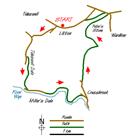
This easy Peak District walk in the Derbyshire dales visits three dales south of the charming village of Litton. There is always something of interest in these limestone dales, Trout in the rivers, Orchids in July and climbers on the crags throughout the year. In general paths are very clear but a little care is required to pick up the correct road from the village.
From Litton Village (Grid ref. SK165751), leave on the minor road in a south westerly direction passing Dale House to the road junction (Grid ref. 155748). Turn left and continue down hill, passing the sewage works on the right to reach a car park and picnic area, which is at the head of Tideswell Dale. Take the path to the right of the toilet block to follow the river down to a lane. Turn left to follow the River Wye downstream through Miller's Dale.
Reaching a collection of cottages note how clear the river is and you should be able to see the large trout. They are quite tame and will react quickly if you flick a small piece of bread into the river. The path now passes through the large derelict building of Litton Mill, notorious for its child labour. Still following the north bank of the river you will notice the river widens to form large pools. You are now in the rather quaintly named Water-cum-Jolly Dale surrounded by high cliffs. The sheer faces on your left are the playground for climbers. All the climbs have been graded and there are many sport climbs, which can be identified by the pre-fixed bolts in the rock face. At the cave you will see many of these bolts.
Just after the cave do not cross over the weir but keep to the north bank to pass another old mill (Grid ref. 173728). Turn left up the lane, keeping to the right hand lane to pass some cottages to enter Cressbrook Dale at a bend in the lane. There used to be a thriving watercress industry in this dale and this is the place to see the Common Spotted Orchid (when in flower the dale is covered with them).
The path wanders through the bushes and trees never far away from the brook before it climbs steeply up the east bank (Grid ref 176745) only to drop back down again into the dale. Keep to the dale passing the impressive Peter's Stone on your right, which is thought to be the place of the last public hanging in this country from the gibbet. The path ends at a road. Turn left and then left again to follow the footpath up the fields to Mires Lane and back to the start.
Messaging & Social Media
Message Walking Britain and follow the latest news.

Mountain Weather
Stay safe on the mountains with detailed weather forecasts - for iOS devices or for Android devices.