Walk 2615 - printer friendly version
The Kinder Edges Walk
Author - Jake Robertson
Length - 18.0 miles / 29.3 km
Ascent - 3400 feet / 1030 metres
Grade - mod/hard
Start - OS grid reference SK124853
Lat 53.364428 + Long -1.8151258
Postcode S33 7ZQ (approx. location only)
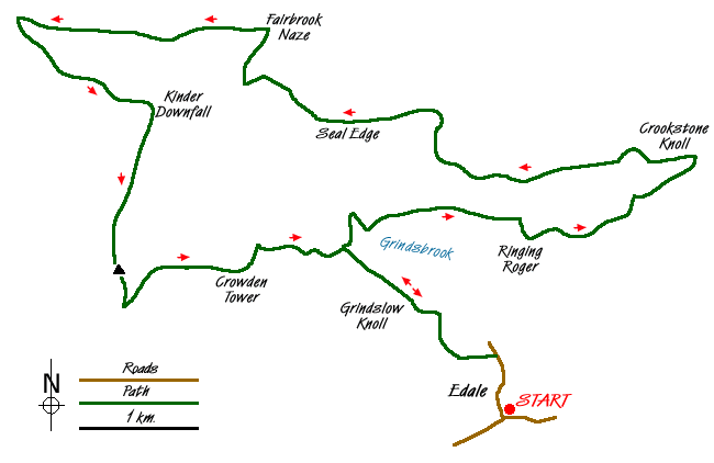
This is one of the classic Peak District walks in the 'Dark Peak', a complete traverse of Kinder's edges. When I did the walk with friends I took 9 ½ hours, ambling at a slow pace to stop and experience the endless delights of the edges. To cap it all off we stopped for tea on the summit, arriving down at Edale covered in peat - a glorious day!
The start of the walk is the main car park in Edale (Grid ref. SK124853) , though one can join the route from a variety of other places.
Leave the car park and head up the road to the post office. Go left with the Pennine Way through the woods until you can fork up the fields to a gate at the foot of Grindslow Knoll. It is a long slog up to the summit but now at least some of the climbing is done. Head NW along Fox Holes to the cairn at the head of Grindsbrook, joining the edges path. Go on, add a stone to it?
I prefer to walk anti-clockwise, saving the busiest parts until last when they should have become quieter. Go north, skirting Grindsbrook Ravine then follow the path east along the edge. Nearing Ringing Roger there is a super view of Grindslow Knoll but the path skirts the summit. The path is clear around Ollerbrook but when there is a fork take the lower path to avoid the Druid's Stone. It is easy going, slightly downhill to the 521m summit of Crookstone Knoll (Grid ref. SK 144883).
The next few hours will be spent on the long northern edge and is the finest part of the walk. From Crookstone Knoll the path becomes indistinct so aim for Madwoman's Stones then by heading NW the edge path will be easily picked up. At first, Blackden Edge is broad and uninteresting but it becomes increasingly dramatic, the path hugs the edge of the massive 500 to 600ft drop into Blackden Clough. After crossing the head, Seal Stones are rounded.
Seal Edge is certainly no less dramatic and shortly after the Chinese Wall, the head of Fairbrook needs to be crossed. Either detour into the plateau or take one of the numerous trods down the small ravine and make the easy scramble out again. The path resumes round to the Pedestal on Fairbrook Naze. To the west, Black Ashop Edge stretches out.
In my opinion, the next two miles along Black Ashop Edge is the finest walk in the Peak District. Sheer 60ft cliffs atop a 600ft sweep down to the Ashop Valley with simply unbelievable views, this a drama to be savoured. The 2050ft summit of The Edge is undoubtedly the highlight of the walk. Sadly, all good things come to an end and reaching the Pennine Way the route swings SE along the edge towards the Kinder Downfall.
Passing the Kinder Downfall, remain with the Pennine Way to the OS column atop Kinder Low. The normal route goes down to Swine's Back then turns left to Noe Stool and The Pagoda. However if you wish, a worthwhile alternative to visit The Peak, Kinder Scout's summit. Take a compass bearing on the 636m spot height and make your way through the wet bogs, arriving with luck at a cairn and stake. This the highest ground in the Peak District and a summit all too fitting to Kinder's boggy nature!
Follow the Pennine Way past Edale Rock. Then bear sharp right along the edge path to Noe Stool and Edale Head. If you have visited the summit then you will rejoin the main path here. Pass Pym Chair and the Pagoda, following the main route. Go east through the weathered Woolpacks to the top of Crowden Tower then down to cross Crowden Brook. An quick walk sees you back at the cairn at Grindsbrook Head. Now simply return to the summit of Grindslow Knoll and descend the same way you ascended, dropping down to Edale. Now, what was that about a pint in the Nag's Head?
Messaging & Social Media
Message Walking Britain and follow the latest news.

Mountain Weather
Stay safe on the mountains with detailed weather forecasts - for iOS devices or for Android devices.